Roelofarendsveen
Coordinates: 52°12′N 4°38′E / 52.200°N 4.633°E
| Roelofarendsveen | |
|---|---|
 | |
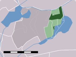
 The town centre (dark green) and the statistical district (light green) of Roelofarendsveen and Oude Wetering in the municipality of Kaag en Braassem. | |
| Country | Netherlands |
| Province | Zuid-Holland |
| Municipality | Kaag en Braassem |
| Population (2009) | 6,989 |
| Major roads | A4 |
Roelofarendsveen is a town in the Dutch province of South Holland. It is a part of the municipality of Kaag en Braassem, and lies about 10 km east of Leiden.
The town Roelofarendsveen and the village Oude Wetering have merged to form one built-up area. The statistical districts covering these two towns have a population of around 10,950.[1]
-
Roelofarendsveen, windmill
-
Roelofarendsveen, watertower in the street
-
Roelofarendsveen, small bridge in the street
References
- ↑ Statistics Netherlands (CBS), Gemeente Op Maat 2004: Alkemade .


