Roecliffe
| Roecliffe | |
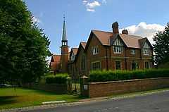 Roecliffe's Church of England primary school |
|
 Roecliffe |
|
| Population | 238 (2011 Census) |
|---|---|
| OS grid reference | SE 375 655 |
| Civil parish | Roecliffe |
| District | Harrogate |
| Shire county | North Yorkshire |
| Region | Yorkshire and the Humber |
| Country | England |
| Sovereign state | United Kingdom |
| Post town | ROECLIFFE |
| Postcode district | YO51 |
| Dialling code | 01757 |
| Police | North Yorkshire |
| Fire | North Yorkshire |
| Ambulance | Yorkshire |
| EU Parliament | Yorkshire and the Humber |
Coordinates: 54°05′17″N 1°25′34″W / 54.088°N 1.426°W
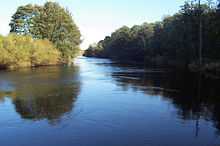
Roecliffe is a village and civil parish in the Harrogate district of North Yorkshire, England. It is situated near the A1 road motorway which connects London with Edinburgh and is 1 mile west of Boroughbridge. It is on the banks of the River Ure and the village centres on the village green which doubles up as the school playing field. The village has a pub The Crown Inn, which offers 5 star accommodation whilst bringing the 16th century back to life.[1] The village itself is surrounded by scenic views with St Mary's Church, Roecliffe as its main attraction in the heart of the village. The church is believed to be the only church in the country with an entirely vaulted roof.[2] Close to Roecliffe are the Dales and the Yorkshire Dales National Park which is known for its spectacular scenery and range of wildlife habitats.[3] Also close by is the village Skelton-on-Ure.
History
Up until 1 October 1998, Roecliffe was part of the Claro Registration District until it was abolished.[4] It was so named after Clara Hill in Allerton Mauleverer parish on the outskirts of Harrogate. It now comes under the North Yorkshire registration district Harrogate[5] which has been described as one of the most spectacular areas of England.[6]
In the 1870s, Roecliffe was described as:
- "ROCLIFF, or Roecliff, a township-chapelry in Aldborough parish, W. R. Yorkshire; on the river Ure, 1½mile W S W of Boroughbridge r. station. Post-town, Boroughbridge, under York. Acres, 1, 794. Real property, £2, 497. Pop., 231. Houses, 53."[7] From this we can tell Roecliffe was a small village with a minimal population back in the day.
Population
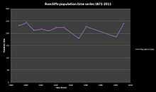
The population in the area has always been small and continues to be so to this day. It had a population of 238 according to the 2011 census.[8] This as shown has fluctuated over time with its most significant decrease in the 1950s where it merely reached 150. Although fluctuations occurred over the years, the population in 2011 is very similar to what it was in 1871 with little difference. There is little evidence to suggest the changes in population figures over time but modern Roecliffe suggests that as the area is fairly small in acres, it is hard to develop in this area and therefore does not give people much reason to move into the area as there is minimal work available.
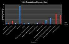
The occupational structure in the area in previous years was fairly simple as there was not much work available for such a small undeveloped area. There were few occupations for the people of Roecliffe, work was simple and mostly handiwork on fields and farms. Agriculture and general workers were the most common occupation for males in the past. However although the majority of females worked in the domestic service, many had jobs that were unspecified so information may be inaccurate. Based on population statistics and the surrounding landscapes, it could be argued that the area has not been developed or built upon over the last 150 years and that the people in the area look for work in nearby villages such as Boroughbridge or may even travel further to look for work. Little development can lead to issues such as limited public transport, few shops, schools and other essential services needed for the people in the area.
Modern day
The area of Roecliffe today has not differed much to its past due to the lack of development and the population size has had minimal change and occupations have spread into other locations, but more care has been given towards the nature and wildlife in the area and public transport runs through the area taking people into nearby neighbouring villages on a daily basis. The villages that surround Roecliffe have had some development over the years but the area still preserves its history.
Transport
Roecliffe does not have many transport options for people to get around, it has one bus service which runs from Ripon to Harrogate. If driving around Roecliffe, there is not a desirable place to park aside the roadside. Across North Yorkshire there are 46 train stops and 5 operators, however the nearest stop to Roecliffe would be Boroughbridge. It is easiest for the people of Roecliffe to use their own transport, cars and bicycles, go on foot or use the bus services provided[9] to go into neighbouring villages.
Education
Roecliffe does not have much to offer for its young people, it has one school, Roecliffe Church of England School, a primary school for the local children, it has outstanding ofsted reports and is becoming more popular every year. The primary school educates children ages 4–11/ years 1–6 with a group for pre-reception children. The staff are all highly dedicated to their work and love their school. The village green sports a 400m track and football pitch. Dogs are banned for health and safety reasons but it is still a great place for children in the village to play and enjoy the village.[10] Further education for secondary school students can be found nearby in Harrogate. Harrogate High School is a mixed school for children aged 11 to 18 and has approximately 720 students.
Roecliffe's Pond and Meadows
The area being so close to the River Ure has plenty of nature and wildlife surrounding it. Once a clay pit in the 19th century, it has been transformed into a private nature reserve.[11] It is now part of the scenic landscape offering many species of wildlife and giving opportunities to its local people such as nature trails and tree climbing. This encourages people to enjoy nature and the countryside as its best. Roecliffe is known for its infamous fishing areas particularly the area surrounding Cherry Island Wood. On a warm sunny day the walk around Roecliffe Ramble will take you from the village starting at the church and along the River Ure[12] passing locks and Newby Hall (an eighteenth-century country house situated on the banks of the river) making it a perfect day for a family outing or just for a stroll in the countryside. Also nearby is a caravan and camping site in Borougbridge allowing tourists, visitors and families to enjoy a camping trip in the scenery with activities such as hiking in mind.
Weather and terrain
Roecliffe is flat surrounded by hilly countryside and close by the upland area of the Yorkshire Dales, as a result the weather is unpredictable but brings about cooler weather than most areas around the UK particularly inner city areas such as London. However, even so, it makes good conditions for outdoor pursuits as long as the right equipment is on hand for the unreliable weather. The coldest month is January where temperatures reach five degrees with the likelihood of snow and barely reaches twenty degrees in the warmest months July and August. The best time to visit would be between May and August where it receives the most sunlight and the least amount of rainy days. The best month would be June as the amount of sunlight is at its highest and rainfall is at its lowest but even so the weather is still unpredictable in the area of Harrogate.[13] Although it may rain at any time, the Pennines mountain range protect the villages below from the prevailing wind and therefore they only see around 150 days of rain on average per annum. This means that in general there is more sunshine than rainfall in the area.[14]
The flat but yet hilly terrain of Roecliffe making up for the acres of woodland and greenery make it a challenging task for quad bikers. The nearest quad biking location to Roecliffe is Bedale which is approximately twenty five minutes drive away from Roecliffe but there are also other locations nearby where quad bikes can be hired for up to an hour.[15]
See also
References
- ↑ "<Roecliffe>(The Crown Inn Pub)". Description of the Crown Inn Pub. The Crown Inn. Retrieved 1 March 2013.
- ↑ "<Roecliffe> (Parish): St. Mary's Church information". Retrieved 4 April 2013.
- ↑ "<Roecliffe> (Parish):Yorkshire Dales Description". Yorkshire Dales National Park. Retrieved 4 April 2013.
- ↑ "<Roecliffe>(Parish):Historic Geographical information". Historic Geographical information Roecliffe. UK & Ireland Geneaology. Retrieved 3 March 2013.
- ↑ "<Roecliffe>(Parish): Claro Registration District History". Roots Web. Retrieved 7 April 2013.
- ↑ "<Roecliffe>(Parish): Harrogate". Welcome to Yorkshire. Retrieved 7 April 2013.
- ↑ Wilson, John (1870–72). Imperial Gazetteer of England and Wales. Edinburgh: A. Fullarton and Co. Retrieved 4 February 2013.
- ↑ "Roecliffe>(Parish): Key Figures for 2011 Census: Key Statistics". Neighbourhood Statistics. Office for National Statistics. Retrieved 4 February 2013.
- ↑ "<Roecliffe> (Parish): Public transport". North Yorkshire County Council. Retrieved 4 April 2013.
- ↑ "<Roecliffe> (Parish): Education in Roecliffe". Roecliffe Church of England School. Retrieved 4 April 2013.
- ↑ "<Roecliffe>(Parish): Description Roecliffe pond and meadows". Neighbourhood Wildlife. Boroughbridge Community. Retrieved 2 March 2013.
- ↑ "<Roecliffe>(parish):Roecliffe wildlife activities". Roecliffe Wildlife activities. Boroughbridge Walks. Retrieved 2 March 2013.
- ↑ "<Roecliffe>(Parish): Climate in Roecliffe". Holiday Check.com. Retrieved 9 April 2013.
- ↑ "<Roecliffe>(Parish): Weather in north west england". met office. Retrieved 9 April 2013.
- ↑ "<Roecliffe>(Parish):Quad biking". Quad Guide. Retrieved 9 April 2013.
External links
![]() Media related to Roecliffe at Wikimedia Commons
Media related to Roecliffe at Wikimedia Commons