Roe Highway
| Roe Highway Western Australia | |
|---|---|
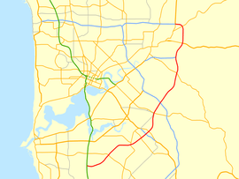 | |
| Map of Perth's central suburbs with Roe Highway highlighted in red | |
| General information | |
| Type | Highway |
| Length | 35 km (22 mi) |
| Opened | 1980s |
| Route number(s) |
|
| Major junctions | |
| Northeast end |
|
| |
| Southwest end |
|
| Location(s) | |
| Major suburbs | Midvale, Hazelmere, Forrestfield, Kewdale, Welshpool, Canning Vale, Leeming, Jandakot |
| Highway system | |
|
Highways in Australia National Highway • Freeways in Australia Highways in Western Australia | |
Roe Highway is a 35 kilometre limited access highway and partial freeway in the south-eastern suburbs of Perth, Western Australia, linking Middle Swan in the north-east with Bibra Lake in the south-west. It is primarily allocated State Route 3 and forms half of Perth's outer ring road along with Reid Highway, which it joins onto at its northern terminus.
The highway is one of the key heavy vehicle routes in the Perth metropolitan area. Aside from intersections, the speed limit is 100 km/h for most of its length. 20 kilometres of the highway, in between Kwinana Freeway and Tonkin Highway, is a continuous freeway, with grade-separated interchanges and free traffic flow. The rest of the highway is the standard of Perth's major highways; limited access, with few grade separations and traffic lights.
Roe Highway is multiplexed with National Highway 94 from Great Eastern Highway Bypass to Great Eastern Highway, and also National Highway 95 from Great Eastern Highway to Great Northern Highway.
Route description
Most junctions on the highway are grade separated diamond interchanges south-west of Tonkin Highway, and at-grade traffic light controlled intersections to the north-east of Tonkin Highway. The exceptions are at: Great Eastern Highway, a modified diamond interchange with a northbound to eastbound loop ramp; Clayton Street and Maida Vale Road, which are grade separated, but with only northbound exit and southbound entry ramps; Berkshire Road (West), a T junction not controlled by traffic lights; Chrisholm Crescent, an uncontrolled left-in/left-out T junction; and the terminus at Kwinana Freeway, a trumpet interchange. There is a diamond interchange at Tonkin Highway, with the free flowing traffic on Tonkin Highway, and traffic light controlled intersections on Roe Highway at the entry and exit ramps.
History
Roe Highway was first proposed in 1955 by Gordon Stephenson as part of what was to become the Metropolitan Region Planning Scheme. The highway was intended to form the southern and eastern sections of a ring route around the Perth metropolitan area.[1] It is named in honour of John Septimus Roe, who arrived in Western Australia in 1829 and served at the first state Surveyor General of Western Australia for 41 years.[2]
Work began in 1981, with the first section between the Beechboro-Gosnells Highway and Bushmead Road opening in 1983. The next section, from Bushmead Road to Great Eastern Highway was opened in 1984. The third stage, linking Great Eastern Highway and Great Northern Highway opened on 14 December 1988, at the same time as the Great Eastern Highway Bypass opened. The state Minister for Transport, Bob Pearce was assisted in the opening ceremony by Jason and Rachael Roe, two of the sixth generation of the Roe family to live in Australia and descendants of John Septimus Roe.[2] The new roads provided a limited access dual carriageway bypass of the historical Guildford and Midland districts that was much needed at the time.
In 1994, the highway was extended 2 km further southwards from Tonkin Highway to Welshpool Road. Following 7 years in hiatus, work recommenced, and in 2001 a new 4 km southwestern extension known as stage 4 was completed from Welshpool Road to the purpose-built Kenwick Link (an Albany Highway bypass built in 1998) - most of which replaced the overtaxed William Street in Beckenham. Work on the 3 km long stage 5 was undertaken simultaneously with stage 4, bringing the highway to Nicholson Road in 2002.
Stage 6, a 5 km extension from Nicholson Road to South Street was completed in 2004, with stage 7 being announced shortly afterwards. The 4.5 km stage 7 extension from South Street to Kwinana Freeway was completed in March 2006, at a cost of A$75m, and represents the highway's current southwestern terminus.[3]
The 19 km of road built since 1994 between Tonkin Highway and Kwinana Freeway, is to a freeway standard. It may in the future be upgraded to a freeway classification.
In June 2012, the new grade separated interchange opened at the Great Eastern Highway intersection, allowing free flowing traffic on Roe Highway over Great Eastern Highway. The design includes a northbound to eastbound loop ramp to cater for heavy vehicles, and three pedestrian underpasses.[4]
Stage 8 / Fremantle Eastern Bypass
In the 1950s, Stephenson planned for Roe Highway to continue westwards from its present terminus at Kwinana Freeway towards Fremantle, through South Fremantle along Marine Terrace and then north to connect with Stirling Highway and the Port of Fremantle. As part of the plan, in 1974 Stirling Highway was extended from its then terminus north of the Swan River southwards to Canning Highway.
A narrow 4 km strip of land immediately south of this intersection was proclaimed for further road construction, but as it was not part of the original Stephenson Plan it was occupied by housing built before the time of Stephenson. Over a period of approximately 20 years, Main Roads Western Australia procured most of the land in question for the future road. In 1985, the first kilometre of this road was constructed, which extended Stirling Highway southwards from Canning Highway to Leach Highway (known as High Street west of Carrington Street). The remaining 3 km strip of land south of High Street then became known as the Fremantle Eastern Bypass.
At the southern end of the proposed Fremantle Eastern Bypass, an 8 km east-west road reservation was proclaimed. This became known as Roe Highway stage 8. This land however was lightly built up and much of it remained as urban bushland throughout the late 20th century. The Roe Highway stage 8 reservation was intended to be the final link of a major urban ring-road, as originally envisioned by Stephenson.
However, there were problems with the proposed link, a product of the changes made by governments since Stephenson's original plan. This included the deletion of the original inner Fremantle section and the proclaiming of the Fremantle Eastern Bypass. Some residents of Fremantle strongly objected to the proposed 4-lane dual carriageway Fremantle Eastern Bypass, claiming it would divide the area, damage urban woodland and impact on 3 nearby schools. Also, the proposed Roe Highway stage 8 would cut between North Lake and Bibra Lake, a location considered of high environmental value as a wetlands. The Environmental Protection Authority in its report on the proposed Roe Highway Stage 8 confirmed the high conservation status of the Beeliar Wetlands and the negative impacts a highway would have on the wetlands.
With a change of state governments in 2001, the planned Fremantle Eastern Bypass / Roe Highway stage 8 was cancelled, with a commitment by the government to sell the land reserved for the Fremantle Eastern Bypass. In doing this, the government put forward a '6-point plan' to cope with the anticipated growth of heavy vehicle traffic in and out of the Port of Fremantle, which included plans for better usage of rail, more efficient usage of trucks and a new deepwater container port near Rockingham. As promised, the Fremantle Eastern Bypass land was sold for a total of $17 million. These funds were then spent on a new grade separated interchange at the intersection of Leach Highway and Orrong Road in Welshpool.
During the period for public submissions on the planned cancellation and sell-off, City of Melville residents opposed the plan[5] as the proposed Fremantle Eastern Bypass / Roe Highway stage 8 would have removed most trucks from Leach Highway, which, although classified as a state highway, travels through a number of residential suburbs. On the other hand the move was generally supported by Fremantle residents including the local MP, and also those concerned by the potential negative impact the proposed road would have on Bibra Lake wetlands.
As part of the funding arrangement for Roe Highway stages 6 and 7, the federal government, which provided some of the funding for those two stages, has stipulated that the Roe Highway stage 8 reservation is to be retained.
Following a change in state governments in September 2008, planning work has now commenced on an extension of the Roe Highway from Kwinana Freeway to Stock Road.[6] Parliamentary debate[7] was continuing in 2012 as the state government continued its intention to implement the plan.
Future
Gateway WA
Gateway WA is a $1 billion project that will upgrade the road network around Perth Airport. It is the largest project Main Roads Western Australia has ever undertaken, covering the upgrade of Tonkin, Leach, and Roe Highways, and the construction of four new interchanges. The project is jointly funded by state and federal governments, which are providing $317.5 million and $686.4 million respectively.[8]
As part of the project, Roe Highway's interchange with Tonkin Highway will be upgraded, noise walls will be erected along Roe Highway in High Wycombe, and a new interchange between Roe Highway and Berkshire Road will be constructed.[8]
Perth Freight Link
The Perth Freight Link is a $1.6 billion project to improve the road freight link between Kewdale and Fremantle. The project includes a five kilometres (3.1 mi) extension to Roe Highway, as well as upgrading Stock Road, Leach Highway, and High Street to provide a grade-separated route, bypassing fourteen sets of traffic signals.[9]
The extension will take the highway from it's current terminus at Kwinana Freeway approximately five kilometres (3.1 mi) further west to Stock Road, near Forrest Road in Coolbellup. The proposed route is along or within the vicinity of an existing road reserve in the Perth Metropolitan Region Scheme.[10]
Interchanges and intersections
| LGA | Location | km | mi | Destinations | Notes |
|---|---|---|---|---|---|
| Swan | Middle Swan | 0 | 0 | Highway terminus: continues west as Reid Highway (State Route 3). National Highway 95 concurrency terminus: continues north. Traffic light controlled intersection | |
| Middle Swan, Stratton | 1.4 | 0.9 | Traffic light controlled intersection | ||
| Swan, Mundaring | Midvale | 3.4 | 2.1 | Morrison Road – Midland, Swan View | Traffic light controlled intersection |
| 4.3 | 2.7 | Modified diamond interchange with northbound to eastbound loop ramp. National Highway 95 terminus. National Highway 94 concurrency terminus: continues east. | |||
| Swan | Bellevue | 5.1 | 3.2 | Clayton Street – Bellevue, Midland | Northbound exit and southbound entry only |
| Hazelmere | 7.1 | 4.4 | National Highway 94 concurrency terminus: continues west; Traffic light controlled T junction | ||
| Kalamunda | High Wycombe, Maida Vale | 9.9 | 6.2 | Traffic light controlled intersection | |
| 11.2 | 7.0 | Maida Vale Road – High Wycombe, Maida Vale | Northbound exit and southbound entry only | ||
| Forrestfield | 13.6– 13.7 | 8.5– 8.5 | Berkshire Road westbound / Berkshire Road eastbound – Forrestfield | Staggered T junctions, Berkshire Road eastbound traffic light controlled | |
| Kewdale, Forrestfield, Wattle Grove | 16.0– 16.2 | 9.9– 10.1 | Diamond interchange (Tonkin Highway free flowing), with traffic lights at each intersection | ||
| Kewdale | 16.8 | 10.4 | Chisholm Crescent – Kewdale | Temporary north-eastbound access via LILO T junction | |
| Gosnells | East Cannington, Welshpool | 18.1 | 11.2 | ||
| Beckenham | 22.3 | 13.9 | |||
| Beckenham, Kenwick, Langford, Thornlie | 22.9– 23.0 | 14.2– 14.3 | Djarlgarra Bridge (over Canning River) | ||
| Gosnells, Canning | Lynwood, Langford, Thornlie, Canning Vale | 25.6 | 15.9 | ||
| Canning | Lynwood, Willetton | 28.2 | 17.5 | Willeri Drive – Canning Vale, Riverton | |
| Leeming | 30.2 | 18.8 | |||
| Cockburn | Jandakot | 33.3 | 20.7 | Dogbone interchange | |
| Bibra Lake, Jandakot, North Lake | 34.2– 34.8 | 21.3– 21.6 | Highway terminus: trumpet interchange | ||
1.000 mi = 1.609 km; 1.000 km = 0.621 mi
| |||||
See also
- Highways in Australia
- Highways in Western Australia
- Freeways in Australia
- Freeways in Western Australia
References
- ↑ New Roe Highway link to open (April 1998). Western Roads: official journal of Main Roads Western Australia, 21(1), p.4. Perth: Main Roads Western Australia.
- ↑ 2.0 2.1 History and a highway (March 1989). Western Roads: official journal of the Main Roads Department, Western Australia, 14(1), p.5. Perth: Main Roads Department.
- ↑ Main Roads, Western Australia, Annual Report 2006. Perth: Main Roads, Western Australia, 2006, p. 51-52
- ↑ "Roe/Great Eastern interchange improves safety, traffic flow and transport efficiency". Ministerial Media Statements. Government of Western Australia. Retrieved 2012-06-11.
- ↑ http://www.wapc.wa.gov.au/Publications/fig4.pdf?id=466
- ↑ http://www.mainroads.wa.gov.au/BuildingRoads/Projects/UrbanProjects/Roe/Pages/roe.aspx
- ↑ http://www.parliament.wa.gov.au/Hansard/hansard.nsf/0/d813b0c9e04bb55b482579f4002a00bd/$FILE/C38%20S1%2020120502%20p2027b-2042a.pdf
- ↑ 8.0 8.1 "Gateway WA". Main Roads Western Australia. 27 March 2013. Archived from the original on 10 May 2013. Retrieved 29 April 2013.
- ↑ Main Roads Western Australia (5 January 2015). "Perth Freight Link". Government of Western Australia. Retrieved 8 February 2015.
- ↑ Main Roads Western Australia (17 December 2014). "Roe Highway Extension - Kwinana Freeway to Stock Road". Government of Western Australia. Retrieved 8 February 2015.
- Hepburn, J.A. & Stephenson, G. 1955, Plan for the metropolitan region, Perth and Fremantle, Western Australia, 1955: a report prepared for the Government of Western Australia, Government Printing Office, Perth.
- Edmonds, Leigh (1997). The vital link: a history of Main Roads Western Australia 1926-1996. Nedlands, Western Australia: University of Western Australia Press. ISBN 1-875560-87-4.
- Main Roads WA
- The Roe7 Project
- Skyview WA - Department of Land Information, Western Australia
| |||||||||||||||||||||
| ||||||||||||||||||||
| |||||||||||||||||||||||||||||||||
Route map: Bing