Rodoanel Mário Covas
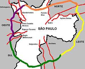
Rodoanel Mário Covas is the planned (and partially built) Greater São Paulo Beltway. Upon its completion, it will have a length of 180 km (110 mi), with a radius of approximately 23 km (14 mi) from the geographical center of the city. It was named after Mário Covas, who was mayor of the city of São Paulo (1983–1985) and a state governor (1994-1998/1998-2001) until his death from cancer. It is a controlled access highway with a speed limit of 100 km/h (62 mph) under normal weather and traffic circumstances.
History
The first section was inaugurated in October 2002, starting at the Estrada Velha de Campinas (lit. Old Road of Campinas), in the northern part of São Paulo, and ending at the Régis Bittencourt highway, in Embu, covering 32 km (20 mi). It crosses Anhangüera, Bandeirantes, Castelo Branco, and Raposo Tavares highways. There are urban accesses to the cities of Osasco and Carapicuíba, but it also crosses through the municipalities of Barueri, Santana de Parnaíba, Embu, Cotia, and São Paulo. The current segment has three tunnels, one of them being the largest and widest one in Brazil, with 1.6 km (0.99 mi), 62 viaducts and six bridges.
On September 15, 2006, the State Government announced the start of the construction of the South Segment, which would link the west segment to the Anchieta and Imigrantes highways and ending in Papa João XXIII Avenue in Mauá. It would serve as a corridor for more than 250,000 trucks per month which must go through the city of São Paulo in order to interconnect to or from the city port of Santos, which is accessible via the two highways cited above. During the construction, a major accident happened when three recently installed ledges fell on the Régis Bittencourt highway, hitting three cars and injuring three people.[1] The construction was expected to take almost five years, mainly due to the complex urban zones and difficult terrain it would cross (including a series of artificial lakes and dams and a mountainous region), but it ended up being inaugurated in April 2010,[2] although some sections were missing guard rails and proper traffic signs.[3]
Upon its completion, estimated for 2018, it will also interconnect the Presidente Dutra, Fernão Dias, and Ayrton Senna (East Segment) main highways, besides many other smaller ones, thus completely surrounding a large area and constituting by far the mightiest road transportation hub in Latin America.
Importance
The São Paulo Beltway is considered a major strategic investment for the efficiency of road transportation in the economically most important region of the country. São Paulo is a megacity, with a population in excess of 20 million inhabitants, and more than 6 million vehicles. Most of the cargo transported by road or other modalities back and forth from the port of Santos today pass through the city of São Paulo generating incredible traffic jams at all hours of the day, with a loss of more than 1.7 billion hours per year (more than 25 million trips a day). Although the city already has an inner beltway (called the Marginals, see Marginal Pinheiros and Marginal Tietê), it is over 30 years old and its capacity is completely saturated since (up until the construction of the Rodoanel) it is the only connection between the major highways around the city of São Paulo. It has been estimated already that more than 30% of the Marginal's traffic was relieved as a consequence.
A recent study, however, has shown that the impact of the Rodoanel in the traffic of São Paulo will be irrelevant, since the number of new cars sold in the city breaks records successively and will quickly compensate the absence of trucks trafficking in the city.[4]
The importance of the Beltway is underlined by popular approval, with June 2004 showing 85% approval rates, 86% of users deeming it a very important resource, and 80% of positive aspects. More than 300,000 vehicles (78% of them automobiles) use the Beltway every day. The system has an estimated peak capacity of 700,000 vehicles per day.
Management
The Western section, completed in 2002, is a toll road managed by a private group called CCR. The newly opened Southern section (2010) is managed by SEMPER, who won the public tender to manage, collect tolls and also to build and collect tolls on the future Eastern section.
See also
References
- ↑ "Vigas recém-instaladas do Rodoanel caem e ferem 3 na Régis; Serra diz que houve falha" (in Portuguese). Folha Online. 14 November 2009. Retrieved 3 April 2010.
- ↑ "Trecho sul do Rodoanel é liberado; rodovias têm lentidão na chegada a SP" (in Portuguese). Folha Online. 1 April 2010. Retrieved 3 April 2010.
- ↑ Cardilli, Juliana (1 April 2010). "G1 percorre novo trecho do Rodoanel Mario Covas" (in Portuguese). G1. Retrieved 3 April 2010.
- ↑ Credencio, José Ernesto; Carvalho, Mario Cesar (14 March 2010). "Rodoanel não vai aplacar tráfego lento em SP, aponta estudo" (in Portuguese). Folha Online. Retrieved 3 April 2010.
External links
| ||||||||||||||