Rochechouart
| Rochechouart | ||
|---|---|---|
|
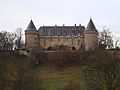
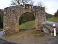
Rochechouart castle | ||
| ||
 Rochechouart | ||
|
Location within Limousin region  Rochechouart | ||
| Coordinates: 45°49′26″N 0°49′18″E / 45.8239°N 0.8217°ECoordinates: 45°49′26″N 0°49′18″E / 45.8239°N 0.8217°E | ||
| Country | France | |
| Region | Limousin | |
| Department | Haute-Vienne | |
| Arrondissement | Rochechouart | |
| Canton | Rochechouart | |
| Intercommunality | Pays de la Météorite | |
| Government | ||
| • Mayor (2008–2014) | Jean-Marie Rougier | |
| Area1 | 53.88 km2 (20.80 sq mi) | |
| Population (2006)2 | 3,930 | |
| • Density | 73/km2 (190/sq mi) | |
| INSEE/Postal code | 87126 / 87600 | |
| Elevation |
159–313 m (522–1,027 ft) (avg. 265 m or 869 ft) | |
|
1 French Land Register data, which excludes lakes, ponds, glaciers > 1 km² (0.386 sq mi or 247 acres) and river estuaries. 2 Population without double counting: residents of multiple communes (e.g., students and military personnel) only counted once. | ||


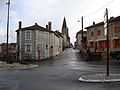
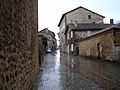
Rochechouart (Rechoard in Occitan, earlier La Ròcha Choard) is a commune in the Haute-Vienne department in the Limousin region in west-central France. It is a sub-prefecture of the department.
The name of the town comes from Latin roca cavardi, which roughly translates as the rock of Cavardus, the lord who had the fortified place built at the beginning of the 11th century. More often than not, natives pronounce it [ʁoˈʃwaʁ], not *[ʁɔʃəˈʃwaʁ] as is its pronunciation in Standard French.
Demographic evolution
- 1962: 4093
- 1968: 4059
- 1975: 4196
- 1982: 4053
- 1990: 3985
- 1999: 3667
- 2006: 3930
Inhabitants are known as Rochechouartais.
Places of interest
The Rochechouart crater is named after the city that covers part of it.
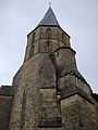
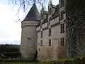
The Château de Rochechouart was built in the 13th century.
Gallery
See also
References
| Wikimedia Commons has media related to Rochechouart. |