Road Up Raritan Historic District
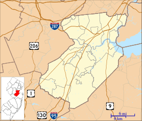
The Road Up Raritan Historic District is located along River Road in Piscataway, Middlesex County, New Jersey.[3] It is north of Raritan Landing, once an important inland port on the Raritan River during the 18th and 19th centuries. The name is taken from an earlier colonial era name for what was once a Lenape path, Assunpink Trail that became a main road parallel to the river.[4][5] Piscataway Township itself was formed on December 18, 1666[6] as one of the first seven townships in East Jersey, and is one of the oldest municipalities in the state.[7] The district includes nine of fourteen historic homes along an approximately 1.2 miles stretch of River Road.[8] The Metlar-Bodine House[9] and the Cornelius Low House are also in the immediate vicinity.
Contributing properties
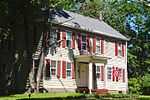
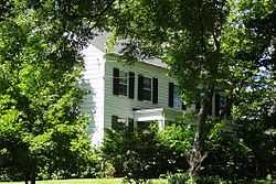
There are seven contributing properties in the district plus two properties that were previously listed.
| Name |
Image |
Address |
Date |
Notes |
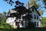
| John Field House |
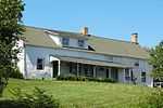 |
625 River Road |
circa 1743 |
|
| W. Dunham House |
 |
649 River Road |
circa 1760 |
Originally Field House |
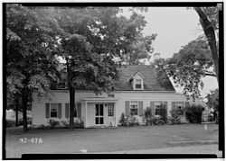
| Isaac Onderdonk House |
 |
685 River Road |
circa 1750 |
Previously listed on the NRHP |
| Lewis Onderdonk House |
 |
701 River Road |
circa 1841 |
|
| John Onderdonk House |
 |
730 River Road |
1854 |
first recorded deed |
| Richard Field, Jr. House |
 |
771 River Road |
circa 1832 |
|
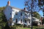
| Matthias Hendricke Smock House |
 |
851 River Road |
circa 1720 |
Previously listed on the NRHP |
| Jonathan Smock House |
 |
871 River Road |
circa 1850 |
|
| Hendrick Smock House |
 |
899 River Road |
circa 1865 |
Also known as Smock-Voorhees House |
See also
References
- ↑ "National Register Information System". National Register of Historic Places. National Park Service. July 9, 2010.
- ↑ "New Jersey and National Registers of Historic Places - Middlesex County". New Jersey Department of Environmental Protection - Historic Preservation Office. May 28, 2014. p. 11.
- ↑ Brecknell, Ursula (September 18, 1997). "NRHP Nomination: Road Up Raritan Historic District". National Park Service.
"Accompanying 49 photos, from 1994–95.".
- ↑ Gabrielen, Randall (2001), Piscataway Township, Arcadia Publishing, ISBN 978-0-7385-0439-1
- ↑ Dalley map 1762 From Perth Amboy to Trenton
- ↑ "The Story of New Jersey's Civil Boundaries: 1606-1968", John P. Snyder, Bureau of Geology and Topography; Trenton, New Jersey; 1969. p. 172.
- ↑ Welcome to Piscataway, NJ, accessed February 8, 2007.
- ↑ "Piscatawy Historic Sites". Piscataway NJ.org. Retrieved 2011-07-05.
- ↑ "Metlar-Bodine House". NJ Proghouse. Retrieved 2011-07-05.
External links
|
|---|
| | Topics | | |
|---|
| | Lists by county | |
|---|
| | Lists by city | |
|---|
| | Other lists | |
|---|
|
-
 Category Category
-
 NRHP Portal NRHP Portal
- New Jersey Portal
|
|
|
|---|
| | Landmarks | | |
|---|
| | Districts | |
|---|
| | Buildings | |
|---|
| | Sites |
- Raritan Landing Archeological District
|
|---|
| | Structures | |
|---|
| |
|

 Media related to Road Up Raritan Historic District at Wikimedia Commons