Rožnik, Grosuplje
| Rožnik | |
|---|---|
|
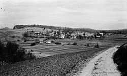
Rožnik in 1948 | |
_location_map.svg.png) Rožnik Location in Slovenia | |
| Coordinates: 45°53′56.2″N 14°38′39.95″E / 45.898944°N 14.6444306°ECoordinates: 45°53′56.2″N 14°38′39.95″E / 45.898944°N 14.6444306°E | |
| Country |
|
| Traditional region | Lower Carniola |
| Statistical region | Central Slovenia |
| Municipality | Grosuplje |
| Area | |
| • Total | 1.67 km2 (0.64 sq mi) |
| Elevation | 461.7 m (1,514.8 ft) |
| Population (2002) | |
| • Total | 47 |
| [1] | |
Rožnik (pronounced [ˈɾoːʒnik]; German: Rosenbach[2]) is a small settlement in the Municipality of Grosuplje in central Slovenia. It lies east of Velike Lipljene just off the regional road leading south from Sveti Jurij to Turjak. The area is part of the historical region of Lower Carniola. The municipality is now included in the Central Slovenia Statistical Region.[3]
References
- ↑ Statistical Office of the Republic of Slovenia
- ↑ Leksikon občin kraljestev in dežel zastopanih v državnem zboru, vol. 6: Kranjsko. 1906. Vienna: C. Kr. Dvorna in Državna Tiskarna, p. 110.
- ↑ Grosuplje municipal site
External links
| Wikimedia Commons has media related to Rožnik, Grosuplje. |

