Rizal, Palawan
| Rizal | |
|---|---|
| Municipality | |
|
Mount Mantalingajan as seen from Ransang, Rizal | |
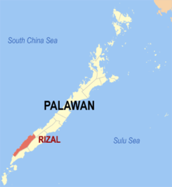
 Map of Palawan with Rizal highlighted | |
.svg.png) Rizal Location within the Philippines | |
| Coordinates: 08°41′N 117°21′E / 8.683°N 117.350°ECoordinates: 08°41′N 117°21′E / 8.683°N 117.350°E | |
| Country | Philippines |
| Region | MIMAROPA (Region IV-B) |
| Province | Palawan |
| Congr. district | 2nd district |
| Founded | April 14, 1983 |
| Barangays | 11 |
| Government[1] | |
| • Mayor | Nicolas T. Montano Sr. |
| Area[2] | |
| • Total | 1,256.47 km2 (485.13 sq mi) |
| Population (2010)[3] | |
| • Total | 42,759 |
| • Density | 34/km2 (88/sq mi) |
| Time zone | PST (UTC+8) |
| Zip Code | 5300 |
| Dialing code | 48 |
| Website |
jprizalpalawan |
Rizal is a first class municipality in the province of Palawan, Philippines. According to the 2010 census, it has a population of 42,759 people.[3]
Prior to its formation as a separate municipality, the place was known as Tarumpitao Point and was part of the Municipality of Quezon. By virtue of National Law No. 386, it was formed as a municipality on April 14, 1983, called Marcos. It was renamed after José Rizal in 1987 through Republic Act No. 6652.[4]
Barangays
Rizal is politically subdivided into 11 barangays.[2]
- Bunog
- Campong Ulay
- Candawaga
- Canipaan
- Culasian
- Iraan
- Latud
- Panalingaan
- Punta Baja
- Ransang
- Taburi
Demographics
| Population census of Rizal | ||
|---|---|---|
| Year | Pop. | ±% p.a. |
| 1990 | 16,819 | — |
| 1995 | 21,876 | +5.05% |
| 2000 | 31,745 | +8.31% |
| 2007 | 35,487 | +1.55% |
| 2010 | 42,759 | +7.02% |
| Source: National Statistics Office[3][5] | ||
References
- ↑ "Municipalities". Quezon City, Philippines: Department of the Interior and Local Government. Retrieved 15 November 2012.
- ↑ 2.0 2.1 "Province: PALAWAN". PSGC Interactive. Makati City, Philippines: National Statistical Coordination Board. Retrieved 22 November 2012.
- ↑ 3.0 3.1 3.2 "Total Population by Province, City, Municipality and Barangay: as of May 1, 2010". 2010 Census of Population and Housing. National Statistics Office. Retrieved 22 November 2012.
- ↑ "Municipal Profile". Municipality of Jose P. Rizal. Retrieved 22 November 2012.
- ↑ "Province of Palawan". Municipality Population Data. LWUA Research Division. Retrieved 18 July 2013.
External links
- Philippine Standard Geographic Code
- Philippine Census Information
- Local Governance Performance Management System
 |
Kalayaan / South China Sea | |
Quezon |  |
| South China Sea | |
Brooke's Point | ||
| ||||
| | ||||
| Bataraza |
| ||||||||||||||
