Rivington Pike
| Rivington Pike | |
|---|---|
 | |
| Elevation | 363 m (1,191 ft) |
| Prominence | c. 15 m |
| Location | |
 Rivington Pike Location in Lancashire | |
| Location | Lancashire, England |
| Range | West Pennine Moors |
| OS grid | SD643138 |
| Coordinates | 53°37′11″N 2°32′28″W / 53.6196°N 2.5411°WCoordinates: 53°37′11″N 2°32′28″W / 53.6196°N 2.5411°W |
| Topo map | OS Landranger 109 |
Rivington Pike is a hill summit on Winter Hill, part of the West Pennine Moors, overlooking the village of Rivington in Lancashire, England. The nearest towns are Adlington and Horwich. The Pike is a prominent local landmark which derives its name from the Old English hreof plus ing meaning the rough or rugged hill and pic, a pointed eminence. The hill was recorded as Rovyng in 1325 and Rivenpike in about 1540. Saxton records the name as Rivenpike Hill on his 1577 map.[1]
Geography and geology

The Pike at 1,191 feet (363 metres) high is the most westerly high point of Winter Hill in the West Pennine Moors. The high moorland is underlain with Carboniferous rocks, the Millstone Grit, sandstones and shales of the Lower Coal Measures which rise high above the Lancashire Plain to the west and Greater Manchester conurbation to the south. The humped shape of the summit coincides with a coal seam of the Lower Coal Measures at around 1,148 feet (350 metres) that outcropped and was mined around 1800. There is evidence of bell pits close to the summit.[2]
The natural vegetation is characterised by areas of blanket bog, impoverished upland heath and acid grassland.[3]
There is an extensive network of footpaths leading to the summit.[4] The highest part of the route to the summit is a footpath and steps built in the 1990s to combat erosion and prevent further deterioration. From the summit it is possible to see Blackpool Tower, the Lake District mountains, the Welsh mountains and as far as the Isle of Man on the clearest days.[5]
History

There are prehistoric sites at Noon Hill tumulus on Winter Hill, at Coblowe hillock by the Lower Rivington Reservoir and it is possible that a standing stone occupied the summit in the prehistoric period.[6] An archaeological dig found evidence of prehistoric activity at nearby Winter Hill but Rivington Pike summit has never been subject to an archaeological survey.[2]
In 1904 author, Fergusson Irvine described the Pike as "the curious hog-backed mound which crowns the summit of the hill and on which stands the Beacon, shows signs of having been at least shaped by artificial means. No doubt it is mainly a natural feature, but there are distinct traces of its having been trimmed and the approach steepened at several points".[6]
Beacon
The prominent summit of Rivington Pike was the site of one of a series of beacons spanning England as an early warning system. The beacon system was put in place by Ranulph de Blundeville, 4th Earl of Chester around 1139,[7] following a Scottish raid in 1138, when a small Lancashire army was defeated near Clitheroe by a much larger Scottish force. The beacon was lit on 19 July 1588 to signal the Spanish Armada was heading towards English shores.[8] Beacons were lit near to the tower for the coronation of King George V in 1910, at the end of the Great War in 1918 and in 1977 and 2012 to celebrate the Silver and Diamond Jubilees of Queen Elizabeth II.
Tower
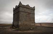
The landmark Pike Tower is a Grade II* listed building on the summit. The tower is square in plan with sides of 16 feet (4.9 m) in length and is 20 feet (6.1 m) high. It was built with a wooden roof, three windows and a door which are now blocked up. The roof was hidden by a parapet with pointed corner and intermediate steps. Inside it retains a fireplace and once had a chimney. Its single room is 13 feet (4.0 m) square with a stone flagged floor and was originally wood panelled. There is a cellar. It was built as hunting lodge in gritstone and was completed in 1733.[9] John Andrews of Rivington Hall built the tower on the site of the beacon using its stone for the foundations. It was built as a watch tower and used for grouse shooting parties.
William Lever gifted land at Lever Park in Rivington to the people of Bolton which included the Pike Tower which was subsequently owned by Liverpool Corporation as part of an agreement for water supplies. The corporation neglected the tower and planned to demolish it in 1967. After a public outcry and legal action the land was transferred to Chorley Rural District Council who restored the building in 1973 and completed further work in the 1990s.[2] The land is now owned by United Utilities.[10]
Events

Rivington Pike Fair held annually on Whit Saturday was moved to Good Friday in 1900. It was held at the highest part of George's Lane, close to the summit. The fair attracted people from Horwich, Chorley and further afield. During the 1830s there was an increase in drunken and riotous behaviour following the fair, which brought prompt and stern measures from the local authorities. Two men from Bolton were charged with "Neglect of Divine Service".[8] The arrival of the Manchester and Bolton Railway's extension to Preston and opening of Blackrod railway station in 1841 brought more visitors which was sustained until the introduction of seaside excursions in about 1860, which led to decline in visitors.
In the early 20th century, car and motorcycle races were held up Rivington Pike. From 1906 to 1912, Bolton motorists witnessed the performance of cars and motorbikes in the hands of some notable drivers of the day on the private roads of the Rivington estate. Under the auspices of the North-East Lancs Automobile Club and the Lancashire Motor-Cycle Club, the first of these hill-climb races took place on 25 July 1906. Competitors were limited to members of the club, and the race was divided into 10 classes according to the list price of the car.[11] In 2011, 4x4 cars caused significant criminal damage in the Chinese gardens and around the pike.[12]
Music festivals and north country fairs were held in the Chinese gardens on the slope of the pike in the summers of 1976 and 1977 and locally named "flower power invasions".[13] Bands included Body, John Peel favourites Tractor, the Damned and Here and Now. The 1976 Rivington Pike Music Festival inspired a group of Rochdale people to launch the Deeply Vale Festivals in mid September 1976.
Sport
The Rivington Pike Fell Race has been held on the Saturday before Easter Sunday since 1892. The fell race originally started from the Horwich railway works, but since 1930 from the park entrance at Lever Park Avenue. It attracts around 400 runners. The course is 3¼ miles and there is a 700 feet ascent.[14][15]
The area is popular with walkers and there is an extensive network of public footpaths providing access to the hillside and surrounding moorland.[16] Many walkers continue the Good Friday tradition of walking to the pike summit.[17]
Folklore
According to folklore, the area around Rivington Pike was the haunt of a spectral horseman, described as demonic or revenant from which a young man is said to have had a lucky escape from in the 1700s.[18]
Nearby hill summits
| Name | Locality | Elevation | OS grid reference |
|---|---|---|---|
| Winter Hill † | Rivington | 1,496 feet (456 m) | |
| Counting Hill | Smithills/Belmont | 1,421 feet (433 m) | |
| Two Lads Hill † | Horwich | 1,276 feet (389 m) | |
| Noon Hill † | Rivington | 1,247 feet (380 m) | |
| Crooked Edge Hill | Horwich | 1,230 feet (375 m) | |
| Rivington Pike | Rivington | 1,191 feet (363 m) | |
| Adam Hill | Horwich | 1,181 feet (360 m) | |
| White Brow | Horwich | 1,175 feet (358 m) | |
| Whimberry Hill | Belmont | 1,115 feet (340 m) | |
| Egg Hillock | Belmont | 1,076 feet (328 m) | |
| Brown Hill | Rivington | 1,066 feet (325 m) | |
| Brown Lowe | Smithills | 1,066 feet (325 m) | |
| Burnt Edge | Horwich | 1,066 feet (325 m) | |
| † Denotes walker's cairn or similar.[19] | |||
References
Notes
- ↑ Mills 1976, p. 126
- ↑ 2.0 2.1 2.2 Winter Hill Scrapbook Vol 2 (PDF), daveweb.co.uk, pp. 10–16, retrieved 2010-05-24
- ↑ The Evolution of Lancashire, Lancashire County Council, retrieved 2010-12-16
- ↑ Country Walking (PDF), Live for the outdoors.com, retrieved 2011-05-13
- ↑ Rivington Pike, Manchester's Countryside, retrieved 2011-05-13
- ↑ 6.0 6.1 Fergusson Irvine 1904, p. 8
- ↑ Pike, bolton.org.uk, retrieved 2010-05-24
- ↑ 8.0 8.1 Hampson 1893, p. ?
- ↑ Rivington Pike Tower, Images of England, retrieved 2010-05-23
- ↑ Warrington to provide a sparkle for Diamond Jubilee, United Utilities, retrieved 2012-08-04
- ↑ Races to the top of Rivington Pike, thisislancashire.co.uk, retrieved 2010-05-24
- ↑ Chris Gee (4 March 2011). "4x4 rampage damages Rivington beauty spot". Lancashire Telegraph. Retrieved May 13, 2011.
- ↑ Smith 1989, p. ??
- ↑ Running Diary, Running Diary, retrieved 2010-06-02
- ↑ Cornthwaite grabs success at Rivington Pike Fell Race, Lancashire Telegraph, retrieved 2010-06-02
- ↑ Moorland Fringe, Lancashire County Council, retrieved 2011-05-13
- ↑ Thousands step up for Good Friday Pike trek, The Bolton News, retrieved 2011-05-13
- ↑ Codd 2011, pp. 131–132
- ↑ Fields, p. 17
Bibliography
- Mills, David (1976), The Placenames of Lancashire, Batsford, ISBN 0-7134-5236-6
- Fergusson Irvine, Wm (1904), A short History of the Township of Rivington in the County of Lancashire, Edinburgh: Ballantyne Press
- Fields, Kenneth, Five half day walks around the West Pennine Moors (2), Lancashire Country Walks
- Hampson, Thomas (1893), A Short History of Rivington, ?
- Smith, M. D. (1989), Rivington, Lancashire, Nelson Brothers Printers Limited, ISBN 0-9508772-8-X
- Codd, Daniel (2011), Paranormal Lancashire, Amberley, ISBN 978-1-4456-0658-3
External links
| Wikimedia Commons has media related to Rivington Pike. |