River Skirfare
| River Skirfare |
|---|
Legend
| |
|
|
Foxup Beck/Cosh Beck |
|
|
|
Foxup Bridge |
|
|
|
Halton Gill Bridge |
|
|
|
Halton Gill Beck |
|
|
|
Newshot Gill |
|
|
|
Unnamed bridge to Nether Hesleden |
|
|
|
Hesleden Gill |
|
|
|
Fording point |
|
|
|
New Bridge on farm track |
|
|
|
Footbridge near Litton |
|
|
|
Potts Beck |
|
|
|
Fosse Beck |
|
|
|
Fording point south of Litton |
|
|
|
Cowside Beck |
|
|
|
Arncliffe Bridge |
|
|
|
Cote Gill |
|
|
|
Footbridge north of Hawkswick |
|
|
|
Hawkswick Bridge |
|
|
|
Sleets Gill Beck |
|
|
|
Moss Beck |
|
|
|
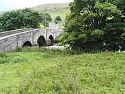
Skirfare Bridge on B6160 |
|
|
|
River Wharfe |
|
|
River Skirfare is a small river in North Yorkshire, England, that flows through Littondale and ends where it joins the larger River Wharfe. The source
is the confluence of Foxup Beck and Cosh Beck at the hamlet of Foxup.
Course
The source of the river is the confluence of Foxup Beck and Cosh Beck at the hamlet of Foxup. To the east bank lays Hawkswick Moor and on the west bank lays Darnbrook Fell, Hawkswick Clowder and Pen-y-ghent Fell. The river meanders consistently south-east for approximately 9.47 miles (15.24 km) to the confluence with the River Wharfe.
Natural history
Main article:
River WharfeThe flora and fauna found along the river are similar to that found along the nearby River Wharfe.
Economy
Main article:
River WharfeThe economy of the area around the river are similar to that found along the nearby River Wharfe.
Lists
Tributaries
From the source of the river:
- Halton Gill Beck
- Newshot Gill
- Hesleden Beck
- Potts Beck
- Fosse Beck
- Cowside Beck
- Cote Gill
- Sleets Gill Beck
- Moss Beck
Settlements
From the source of the river:
Crossings
From the source of the river:
- Foxup Bridge
- Halton Gill Bridge
- Unnamed bridge to Nether Hesleden
- Fording point
- New Bridge on farm track
- Footbridge near Litton
- Fording point south of Litton
- Arncliffe Bridge
- Footbridge north of Hawkswick
- Hawkswick Bridge
- Skirfare Bridge on B6160
Gallery
| Along the River Skirfare |
|---|
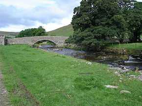
| River Skirfare passing through Halton Gill |
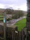
| Litton walking sign on Halton Gill Bridge |
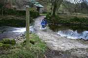
| Ford, River Skirfare near Litton |
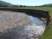
| River erosion near Arncliffe, Littondale, Yorkshire Dales |
| Footbridge on Old Gang Lane, Hawkswick |
| Skirfare Bridge near confluence with River Wharfe |
|
Sources
- OS Landranger Map Wensleydale & Upper Wharfedale Sheet 98
- OS Explorer Map Yorkshire Dales: N & Cen areas Sheet OL30
Rivers of Yorkshire |
|---|
| | North Yorkshire | |
|---|
| | West Yorkshire | |
|---|
| | East Riding of Yorkshire | |
|---|
| | South Yorkshire | |
|---|
|