River Seven
| River Seven | |
| River | |
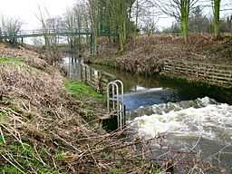 The Seven near Normanby |
The River Seven is a river in North Yorkshire, England.
The River Seven rises on Danby High Moor, in the middle of the North York Moors, and flows south for about 15 miles or 25 km to meet the River Rye, at Brawby.
After leaving Danby High Moor, the river flows through Rosedale and passes Rosedale Abbey. In its lower course, it meanders due to interlocking spurs. A number of villages lie along the lower course of the River Seven. Some of these date from the 12th century or earlier, and likely none of them would exist if not for the river. For early settlers, the river may have been the only source of water and fertile land in its flood plains. They relied on the river for fishing, and washing. There are fossils in the sedimentary layers in the river, in the Jurassic layer of rock.
Geology
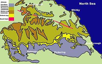
The River Seven is a small river, with not much influence on the geology of the area, although over time it has exposed various rock zones. The lacustrine deposits from the last ice age are exposed and visible in the bed of the river. There are three different time zones (periods) in the area.
- Lower Jurassic
- Middle Jurassic
- Upper Jurassic
The rock types consist of : Corallian Limestone (top layer), Oxford Clay, Raven-scar Limestone and Shales and Ironstone.
These are split up depending on their rock band and type. Over time the North York Moors are sliding downhill: you can tell this from the new bands of rock visible in the northern regions.
Geographical study
Recent surveys of the river from 12 August 2008 revealed this information about the River Seven.
- Average Velocity
The river's velocity increases, dependent on the (km) from source.
The velocity of the river Seven is affected by its gradient. A high gradient, as observed near the source, speeds up the flow of the river, with the lower section having shallower gradients and exhibiting meanders. However, the volume of water and channel roughness dominate flow velocities, with the steeper upland channel sections having lower flow volumes and increased friction from channel obstructions such as boulders. Lower section have large, smooth cross section with larger flow volumes, and subsequently greater velocities of flow.
Settlements
- Thorgill
- Rosedale Abbey
- Cropton
- Appleton-le-Moors
- Sinnington
- Marton
- Normanby
- Great Barugh
- Brawby
References
http://www.normanby.info/riverseven.htm