River Peck
Coordinates: 51°27′29″N 0°03′32″W / 51.4581°N 0.0588°W
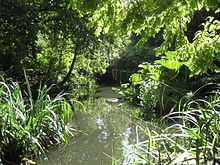
The River Peck in in the Japanese Garden, Peckham Rye park

This stone marks the boundary between St Mary's parish, Rotherhithe and St Paul's parish, Deptford. Until 1899 this was also the Kent-Surrey boundary. The stone was on a bridge over the Earl Creek nearby, but was relocated here in 1988.
River Peck is a small stream in London that was enclosed in 1823. Today, parts of this stream can still be seen on the west side of Peckham Rye Park. In South Bermondsey it joins with the Earl's Sluice and then empties into the Thames at Deptford Wharf.
See also
References
External links
- Lost Rivers from Above: The Peck on Londonist blog.
- River Peck on Diamond Geezer blog.