River Kyle
| River Kyle | |
|---|---|
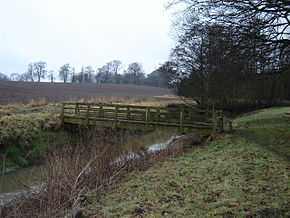 Footbridge over River Kyle at Alne 54°4′41.41″N 1°14′28.56″W / 54.0781694°N 1.2412667°W | |
| Origin |
Confluence of Derrings Beck and Carle Beck nr Tholthorpe 54°5′24″N 1°15′38″W / 54.09000°N 1.26056°W |
| Mouth | 54°2′5″N 1°13′28″W / 54.03472°N 1.22444°W |
| Basin countries | England |
| Length | 9.31 kilometres (5.78 mi) |
| Source elevation | 12 metres (39 ft) |
| Mouth elevation | 11 metres (36 ft) |
The River Kyle is a small river in North Yorkshire, England. At just under 6 miles long, it is one of the shortest classified main rivers in the country.
Course
The river is first called Kyle after the confluence of Carle Beck and Derrings Beck. From the confluence it flows south-east of the village of Tholthorpe, near Easingwold, past Flawith, Alne and Tollerton. At Linton-on-Ouse it turns south and joins the River Ouse just north of Newton-on-Ouse.
History
The river previously formed the boundary of the Forest of Galtres. During the Second World War, RAF Bomber Command operated an airfield near the start of the River Kyle at RAF Tholthorpe. Both the Royal Air Force and the Royal Canadian Air Force flew from this base until its closure in 1945.[1] The river also passes close to the current airfield at RAF Linton-on-Ouse, which was originally opened in 1937 as part of RAF Bomber Command.
Leisure
There are two Ordnance Survey Leisure Walking routes that cross the river near Tollerton.[2][3]
Lists
Tributaries
|
Settlements
|
Crossings
|
Gallery
-
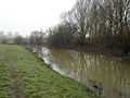
River Kyle north of Linton-on-Ouse
-
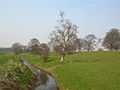
River Kyle at Tollerton
-
River Kyle from Carrholme Bridge
Sources
- Orndance Survey Open Viewer
- Google Earth
- National Environment Research Council - Centre for Ecology and Hydrology
- Environment Agency
References
| ||||||||||||||||||