River Kennett
For the river in Berkshire and Wiltshire, see River Kennet. For other uses, see Kennet River (disambiguation).
| River Kennett | |
| River | |
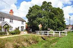 River Kennett at Dalham, dry in August, 2005 | |
| Country | England |
|---|---|
| County | Suffolk |
| Source | |
| - location | near Dalham, Suffolk, East Anglia, England |
| - coordinates | 52°13′12″N 0°30′35″W / 52.22000°N 0.50972°W |
| Mouth | Lee Brook |
| - location | near Freckenham, Suffolk, England |
| - elevation | 0 m (0 ft) |
| - coordinates | 52°19′0.12″N 0°25′58.8″W / 52.3167000°N 0.433000°WCoordinates: 52°19′0.12″N 0°25′58.8″W / 52.3167000°N 0.433000°W |
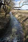
The River Kennett rises south of Dalham in Suffolk, and flows northward past Moulton and Kennett, and joins Lee Brook, a tributary of the River Lark, just south of Freckenham.[1] The river is generally dry in the summertime.
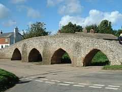
At Moulton the river passes under a Grade-II*-listed 15th-century packhorse bridge. This bridge has four arches, indicating that the river was larger when the bridge was constructed.[2]
References
- ↑ Jones, Bob (6 March 2009). "River Kennett at Badlingham". Wikimedia Commons. Retrieved 2012-11-09.
The River Kennett becomes Lee Brook at Freckenham, and joins the River Lark near West Row.
- ↑ "History and Research Moulton Packhorse Bridge". English Heritage. Retrieved 16 November 2012.
|
| ||||||||||||||