River Derwent, North East England
Coordinates: 54°50′38″N 2°04′01″W / 54.844°N 2.067°W
| River Derwent | |
|---|---|
|
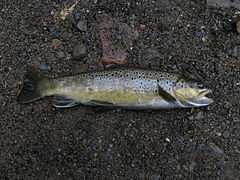
A Brown Trout caught on the River Derwent, known locally as a "Broon Troot" | |
 Source of the River Derwent | |
| OS grid reference | NY957498 |
| |
The River Derwent is a river on the border between County Durham and Northumberland in the north east of England. It broadens into the Derwent Reservoir, west of Consett. The Derwent is a tributary of the River Tyne, which it joins near the MetroCentre. The river flows for 35 miles from its origin, where two streams meet approximately a mile west of Blanchland, to Derwenthaugh where it flows into the River Tyne. On its journey, the river flows through places such as Allensford, Shotley Bridge, Blackhall Mill and Rowlands Gill. The river is known locally as "The Divvy" . Derwent Walk Country Park named after it is at Rowlands Gill. Fishing permits on the river are usually priced at £3.00 on each stretch.
The name Derwent comes from the Brythonic/Early Welsh word for oak derw and valley -went ( alternatively water dour / der/ dar and white (g)-went , See under ' DUR ' http://freepages.genealogy.rootsweb.ancestry.com/~pbtyc/Misc/Etymology.html , harking back to the time when the Derwent Valley was inhabited by a British-speaking population.
External links
| Wikimedia Commons has media related to River Derwent, North East England. |