River Brue
| River Brue | |
| River | |
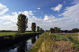 River Brue near Glastonbury | |
| Country | England |
|---|---|
| County | Somerset |
| District | Somerset Levels |
| Tributaries | |
| - left | River Pitt |
| - right | River Alham, Whitelake River |
| Cities | Bruton, Glastonbury, Highbridge |
| Landmark | Westhay Moor |
| Source | |
| - location | Brewham, South Somerset, Somerset, England |
| - coordinates | 51°07′49″N 2°22′43″W / 51.13028°N 2.37861°W |
| Mouth | Bristol Channel |
| - location | Highbridge, Somerset, Somerset, England |
| - coordinates | 51°13′32″N 3°00′13″W / 51.22556°N 3.00361°WCoordinates: 51°13′32″N 3°00′13″W / 51.22556°N 3.00361°W |
The River Brue originates in the parish of Brewham in Somerset, England, and reaches the sea some 50 km west at Burnham-on-Sea. It originally took a different route from Glastonbury to the sea, but this was changed by the monastery in the twelfth century.
The Brue Valley Living Landscape is a conservation project based on the Somerset Levels and Moors and managed by the Somerset Wildlife Trust. The project commenced in January 2009 and aims to restore, recreate and reconnect habitat. It aims to ensure that wildlife is enhanced and capable of sustaining itself in the face of climate change[1] while guaranteeing farmers and other landowners can continue to use their land profitably. It is one of an increasing number of landscape scale conservation projects in the UK.[2][3][4]
Course
The River Brue originates in the same hills as King Alfred's Tower and the sources of the River Wylye and the Dorset Stour.[5] It falls quickly in a narrow valley to a point just beyond Bruton where it is joined by the River Pitt. Here it takes a meandering route through a broad, flat-bottomed valley between Castle Cary and Alhampton. By the time it reaches Baltonsborough it is only some 10m above sea level and the surrounding countryside is drained into it by way of numerous rhynes. It passes Glastonbury, where it acts as a natural boundary with nearby village of Street, before flowing in a largely artificial channel across the Somerset Levels and into the River Parrett at Burnham-on-Sea. It is joined by the North Drain, White's River (which takes the water of the River Sheppey, Cripps River (an artificial channel that connects it to the River Huntspill) and many drainage rhynes. It is tidal below the sluices at New Clyce Bridge in Highbridge.[6][7]
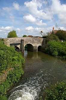
Bow Bridge is a 15th-century Packhorse bridge over the River Brue in Plox, Bruton. It has been designated as a Grade I listed building,[8] and Scheduled Ancient Monument.[9] The bridge may have been built as a link between the former Bruton Abbey, and its Court House in the High Street.[8] The bridge was restored after floods on July 12, 1982.
The River Brue has a long history of flooding. Its lower reaches are close to sea-level, and the river above Bruton drains an area of 31 km2 into a steep and narrow valley. In 1768 the river rose very rapidly and destroyed a stone bridge in Bruton. In 1984 a protective dam was built 1 km upstream from the town.[10][11]
The valley includes several Sites of Special Scientific Interest including Westhay Moor.
History
Pomparles Bridge
At the time of King Arthur the Brue formed a lake just south of the hilly ground on which Glastonbury stands. This lake is one of the locations suggested by Arthurian legend as the home of the Lady of the Lake. Pomparles Bridge stood at the western end of this lake, guarding Glastonbury from the south, and it is suggested that it was here that Sir Bedivere threw Excalibur into the waters after King Arthur fell at the Battle of Camlann.[12]
John Leland noted in the 16th century that the bridge had four arches, while W.Phelps in an 1839 illustration as having only two arches, one pointed, probably C14-15, and the other round. Excavations in 1912 found the remains of a second round arch regarded as C12 work. The current concrete arch bridge was built in 1911 and extended in 1972.[13] It carries the A39 road over the Brue.
Alteration of route
Prior to the 13th century the direct route to the sea at Highbridge was prevented by gravel banks and peat near Westhay.[14] The course of the river partially encircled Glastonbury from the south, around the western side (through Beckery),[15] and then north through the Panborough-Bleadney gap in the Wedmore-Wookey Hills, to join the River Axe just north of Bleadney. This route made it difficult for the officials of Glastonbury Abbey to transport produce from their outlying estates to the Abbey, and when the valley of the river Axe was in flood it backed up to flood Glastonbury itself. Sometime between 1230 and 1250 a new channel was constructed westwards into Meare Pool north of Meare, and further westwards to Mark Moor. It then divided into two channels, one the Pilrow cut flowing north through Mark to join the Axe near Edingworth, and the other directly west to the sea at Highbridge.[16]
Drainage improvements
Between 1774 and 1797 a series of enclosures took place in the Brue valley between the Poldens and Wedmore.[16] In 1794 the annual floods filled the whole of the Brue valley. Work by the Commissioners of Sewers led to the 1801 Brue Drainage Act which enabled sections at Highbridge and Cripp's Bridge to be straightened, and new feeder channels such as the North and South Drains to be constructed.[17] In 1803 the clyse at Highbridge, which had been built before 1485, was replaced and moved further downstream.[16]
The River Brue has a long history of flooding in Bruton. In 1768 the river rose very rapidly and destroyed a stone bridge.[18] On the 28 June 1917, 242.8 mm of rain fell in 24 hours at Bruton,[19] leaving a water mark on one pub twenty feet above the normal level of the river.[20] In 1984 a protective dam was built 1 km upstream from the town.[10]
River mouth
The mouth of the River Brue had an extensive harbour in Roman and Saxon times, before silting up in the medieval period. It was used again as a small harbour in the 17th and 18th centuries, and in 1833 the port of Highbridge was formally opened on the river. A new wharf, known as Clyce Wharf, was built on the Huntspill side of the river mouth by 1904, and was used for the import of coal and the export of bricks and tiles and agricultural products. The port closed in 1949.[21]
Canals
Both Galton's Canal and Brown's Canal once connected to the river.[22] The Glastonbury Canal used the course of the River Brue from Highbridge to Cripp's Bridge, and part of the South Drain to Ashcott Corner.[17]
Second World War
During the Second World War the Brue was incorporated into GHQ Line and many pillboxes were constructed along the river.[23]
Economy
Gants Mill at Pitcombe, near Bruton, is a watermill which is still used to mill cattle feed. A 12 kW hydroelectric turbine was recently installed at the site. There has been a mill here since the 13th century, but the current building was built in 1810.
During monastic times, there were several fish weirs along the lower reaches of the river. They used either nets or baskets, the fishing rights belonging to the Bishop of Bath and Wells and the Abbot of Glastonbury.[24]
Recreation
Anglers will find pike in excess of 20 lb, with good stocks of chub, dace, roach, bream, tench, perch, rudd, and gudgeon. There are trout in the upper reaches.[25]
There are several access points along the river suitable for canoeing, and the river has been paddled as far up as Bruton, but above West Lydford only after recent rain.[26] There are public footpaths alongside many stretches of the river.[6]
References
- ↑ Brue Valley Living Landscape
- ↑ A Living Landscape - The Wildlife Trusts
- ↑ RSPB landscape conservation
- ↑ Natural England Future Landscapes
- ↑ Lewis, Samuel (the younger) (1855). The Book of English Rivers. London: Longman, Brown, Green, and Longmans. pp. 50–51.
- ↑ 6.0 6.1 Explorer 153, 141, 142 (Map). Ordnance Survey. Retrieved 2008-11-04.
- ↑ "Somerset Topography: Rivers". Somerset County Council. Retrieved 2008-11-07.
- ↑ 8.0 8.1 "Bow Bridge". Images of England. English Heritage. Retrieved 2009-07-03.
- ↑ "Bow Bridge (also known as The Packhorse Bridge), Plox (North West side), Bruton". Somerset Historic Environment Record. Somerset County Council. Retrieved 2009-07-03.
- ↑ 10.0 10.1 Clark, Colin (2004). "Real-time flood forecasting". International Water Power and Dam Construction website. Progressive Media Markets Ltd. Retrieved 2008-11-06.
- ↑ Singh, Vijay P. (December 15–18, 2003). Watershed Hydrology: Proceedings of the International Conference on Water and Environment. Bhopal, India: Allied Publishers. pp. 426, 485–488. ISBN 978-81-7764-547-7.
- ↑ "Pomparles Bridge". ArthurianAdventure.com. Retrieved 2008-11-01.
- ↑ "Pomparles Bridge, Northover, Glastonbury". Somerset Historic Environment Record. Retrieved 2008-11-01.
- ↑ "Meare and Ferran Mere". Sacred Sites around Glastonbury. Retrieved 2008-11-01.
- ↑ "Glastonbury Map B — Dark Age/Saxon". Somerset County Council. 2003. Retrieved 2008-11-07.
- ↑ 16.0 16.1 16.2 Havinden, Michael (1981). The Somerset Landscape. The making of the English landscape. London: Hodder and Stoughton. pp. 110–111. ISBN 0-340-20116-9.
- ↑ 17.0 17.1 Body, Geoffrey; Gallop, Roy (2001). The Glastonbury Canal. Bristol: Fiducia Press. ISBN 0-946217-08-4.
- ↑ Singh, Vijay P. (December 15–18, 2003). Watershed Hydrology: Proceedings of the International Conference on Water and Environment. Bhopal, India: Allied Publishers. pp. 426, 485–488. ISBN 978-81-7764-547-7.
- ↑ "The Boscastle storm of August 2004 and other heavy rainfall events of the last century in the area". wiseweather.co.uk. Retrieved 2008-11-06.
- ↑ Simons, Paul (June 27, 2007). "June's freak downpours have historical precedent". The Times (London). Retrieved 2008-11-06.
- ↑ Robert Dunning, ed. (2004). "Huntspill". A History of the County of Somerset: Volume 8, the Poldens and the Levels. Victoria County History. British History Online. pp. 91–112. Retrieved 25 January 2015.
- ↑ Hadfield, Charles (November 1967). The Canals of South West England. Newton Abbot (Devon): David & Charles. pp. 190–191. ISBN 0-7153-4176-6.
- ↑
- Foot, William (2006). Beaches, fields, streets, and hills ... the anti-invasion landscapes of England, 1940. Council for British Archaeology. pp. 267–272. ISBN 1-902771-53-2.
- ↑ Rippon, Stephen. ahds/dissemination/pdf/vol48/48_091_130.pdf "Making the Most of a Bad Situation? Glastonbury Abbey, Meare, and the Medieval Exploitation of Wetland Resources in the Somerset Levels". ArchaeologyDataService.ac.uk. pp. 30–31. Retrieved 2008-11-04.
- ↑ "Club Waters". Glaston Manor Angling Association website. Retrieved 2008-11-06.
- ↑ Lambert, David. "River Brue". British Canoe Union South West. B.C.U. Local Access Officer. Retrieved 2008-11-06.