River Beane
| Beane | |
| River | |
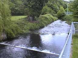 Weir on the River Beane, Hartham Common | |
| Country | United Kingdom |
|---|---|
| Source | |
| - location | Nr. Sandon, Hertfordshire |
| - elevation | 90 m (295 ft) |
| Mouth | |
| - location | Hertford, Hertfordshire into River Lea |
| Length | 17.8 km (11 mi) |
The River Beane is a short river in the county of Hertfordshire, England. A tributary of the River Lea, it rises to the south-west of Sandon in the hills northeast of Stevenage and joins the Lea at Hartham Common in Hertford.
Hertfordshire's population increased substantially in the second half of the twentieth century, and has affected rivers such as the Beane and the Mimram. In the case of the Beane, a licence was given to abstract water near Aston for Stevenage's water supply. The river has since been adversely affected by over-exploitation of the chalk aquifer in its upper reaches. The photo shows a section south of Walkern where since the 1990s there has been only seasonal flow. The river was once big enough to power a watermill at Walkern and support watercress beds.
The lower Beane is more robust and there is regular flow through Watton-at-Stone, Stapleford and Waterford until the confluence with the River Lea. However, overall the river has performed badly in assessments by the Environment Agency of flow level. Consideration has been given to find a way of replacing the water currently abstracted near Aston with water from a less environmentally damaging source. However, the River Lea's catchment area as a whole is under pressure, and it is difficult to find another source of fresh water. One possible approach to the restoration of the upper Beane is to use recycled water from sewage treatment works. Currently sewage from the Stevenage area is pumped down the Beane valley to Rye Meads near Hertford for treatment.[1]

References
| Wikimedia Commons has media related to River Beane. |
External links
- Press release for WWF report "Riverside Tales", 2010-04-28, WWF-UK
- Launch of the WWF report on the Rivers Beane and Mimram, Oliver Heald MP comments on WWF report.
- Beane and Mimram Rivers Partnership
| ||||||||||||||||||||||
Coordinates: 51°47′N 0°05′W / 51.783°N 0.083°W