River Bain, North Yorkshire
| River Bain | |
|---|---|
| Origin | 54°17′3″N 2°7′22″W / 54.28417°N 2.12278°W |
| Mouth |
River Ure (at Bainbridge) 54°18′45″N 2°6′3″W / 54.31250°N 2.10083°W |
| Basin countries | England |
| Length | 3.95 kilometres (2.45 mi) |
| Source elevation | 252 metres (827 ft) |
The River Bain is a river in North Yorkshire, England. It is designated legally as a Main River, so at around two and a half miles long is reputed to be the shortest river in England. The Brennand River in Lancashire is half the distance, but as it is a tributary to other tributaries, it is not classified as a Main River. The river is home to the small scale hydroelectricity project River Bain Hydro located at Bainbridge.[1]
Course
The river leaves the second-largest natural lake in North Yorkshire, Semerwater, in a north-east direction past the hamlet of Countersett.[2] After a couple of gentle meanders it runs though woodland before slowly turning northward. It passes under the A684 road in Bainbridge and joins the River Ure to the east of Yore Bridge opposite the mouth of Grange Beck.
Images
-
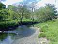
River Bain leaving Semerwater
Sources
References
- ↑ "Official switch on for river Bain hydro". Resonance Limited. 17 May 2011. Retrieved 13 February 2012.
- ↑ "Semerwater". Retrieved 27 February 2011.
| ||||||||||||||||||