Ritter (crater)
|
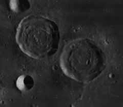
The crater pair Sabine (center right) and Ritter (right). NASA photo. | |
| Coordinates | 2°00′N 19°12′E / 2.0°N 19.2°ECoordinates: 2°00′N 19°12′E / 2.0°N 19.2°E |
|---|---|
| Diameter | 29 km |
| Depth | 1.3 km |
| Colongitude | 341° at sunrise |
| Eponym |
Carl Ritter Georg August Dietrich Ritter |


Ritter is a lunar crater located near the southwestern edge of Mare Tranquillitatis. It is the northwestern member of a crater pair with Sabine to the southeast. The two rims are separated by a narrow valley only a couple of kilometers wide. To the northwest is the crater Dionysius, and to the north-northeast are Manners and Arago. This crater is roughly circular but with an irregular outer rim. The inner walls have slumped down towards the floor. The interior is irregular with several low ridges. To the northwest of Ritter is a system of parallel rilles designated Rimae Ritter. These follow a course to the northwest.
Ranger 8 flew over Ritter prior to impact in Mare Tranquilitatis.
Both Sabine and Ritter were originally believed to be calderas rather than impact craters. In To A Rocky Moon, lunar geologist Don E. Wilhelms summarized: "They are identical twins in morphology and size (29-30 km). They lack radial rim ejecta and secondary craters despite their apparent youth. They are positioned at the presumably active edge of a mare. They are even aligned along graben, the Hypatia rilles. Most significant, they lack deep floors recognized since the days of Gilbert as diagnostic of impacts." However, after the Apollo landings were complete, it was realized that "all craters inside basins suffer enhanced isostatic uplift," because "the thin crust and greater heat inside basins lower the viscosity of the craters' substrate, allowing it to reach isostasy with its surroundings more quickly than can other craters."[1]
Satellite craters
By convention these features are identified on lunar maps by placing the letter on the side of the crater midpoint that is closest to Ritter.
| Ritter | Latitude | Longitude | Diameter |
|---|---|---|---|
| B | 3.3° N | 18.9° E | 14 km |
| C | 2.8° N | 18.9° E | 14 km |
| D | 3.7° N | 18.8° E | 7 km |
External links
References
| Wikimedia Commons has media related to Image:AS11-41-6121.jpg. |
- ↑ To a Rocky Moon: A Geologist's History of Lunar Exploration. Don E. Wilhelms, University of Arizona Press (1993). ISBN 978-0816510658
- Andersson, L. E.; Whitaker, E. A. (1982). NASA Catalogue of Lunar Nomenclature. NASA RP-1097.
- Blue, Jennifer (July 25, 2007). "Gazetteer of Planetary Nomenclature". USGS. Retrieved 2007-08-05.
- Bussey, B.; Spudis, P. (2004). The Clementine Atlas of the Moon. New York: Cambridge University Press. ISBN 978-0-521-81528-4.
- Cocks, Elijah E.; Cocks, Josiah C. (1995). Who's Who on the Moon: A Biographical Dictionary of Lunar Nomenclature. Tudor Publishers. ISBN 978-0-936389-27-1.
- McDowell, Jonathan (July 15, 2007). "Lunar Nomenclature". Jonathan's Space Report. Retrieved 2007-10-24.
- Menzel, D. H.; Minnaert, M.; Levin, B.; Dollfus, A.; Bell, B. (1971). "Report on Lunar Nomenclature by the Working Group of Commission 17 of the IAU". Space Science Reviews 12 (2): 136–186. Bibcode:1971SSRv...12..136M. doi:10.1007/BF00171763.
- Moore, Patrick (2001). On the Moon. Sterling Publishing Co. ISBN 978-0-304-35469-6.
- Price, Fred W. (1988). The Moon Observer's Handbook. Cambridge University Press. ISBN 978-0-521-33500-3.
- Rükl, Antonín (1990). Atlas of the Moon. Kalmbach Books. ISBN 978-0-913135-17-4.
- Webb, Rev. T. W. (1962). Celestial Objects for Common Telescopes (6th revised ed.). Dover. ISBN 978-0-486-20917-3.
- Whitaker, Ewen A. (1999). Mapping and Naming the Moon. Cambridge University Press. ISBN 978-0-521-62248-6.
- Wlasuk, Peter T. (2000). Observing the Moon. Springer. ISBN 978-1-85233-193-1.
