Rippleside, Victoria
| Rippleside Geelong, Victoria | |||||||||||||
|---|---|---|---|---|---|---|---|---|---|---|---|---|---|
 | |||||||||||||
| Population | 439 (2011 census)[1] | ||||||||||||
| Postcode(s) | 3215 | ||||||||||||
| LGA(s) | City of Greater Geelong | ||||||||||||
| State electorate(s) | Lara | ||||||||||||
| Federal Division(s) | Corio | ||||||||||||
| |||||||||||||
Rippleside is a suburb of Geelong, Victoria, Australia. The suburb overlooks Corio Bay. At the 2011 census, Rippleside had a population of 439.[1]
History
Geelong's early settlers targeted the area which is now Rippleside because of its convenience close to the Melbourne-Geelong Road which runs vertically to Rippleside Park. By 1854 after Geelong settlers choose their lands, The Rippleside Hotel and local General Store were opened. In 1857 the Melbourne-Geelong railway was opened, and the North Geelong railway station was opened and began operating soon after.
The Post Office opened on 19 May 1986, replacing the nearby North Geelong office.
Rippleside Park
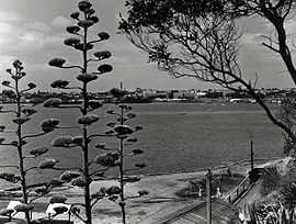
Rippleside Park is in the suburb of Rippleside; Rippleside adjoins Drumcondra, 2.5 kilometres (1.6 mi) north of Geelong City on Corio Bay. The locality is part of North Geelong and covers the suburban area bounded by Corio Bay, Victoria Street, Melbourne Road and Rippleside Park.
Rippleside Park is a much sought-after location in Geelong; many of the properties located in the area represent the Victorian history that the area has experienced throughout its life. Rippleside Park is used for many events that happen throughout Geelong. The City Council is responsible for the appearance of the Park.
Rippleside Park over-looks Corio Bay and houses in the area are quickly sold, some of Geelong's most expensive homes are located in Balmoral Crescent and Liverpool Street, which are the two streets located on edge of Rippleside Park and the cliff over-looking Corio Bay in the suburb of Rippleside. The location of the area is extremely convenient to the residents; it is within 2 kilometres (1.2 mi) of the North Geelong Railway Station and is within walking distance of Geelong City.
Notes
- ↑ 1.0 1.1 Australian Bureau of Statistics (31 October 2012). "Rippleside (State Suburb)". 2011 Census QuickStats. Retrieved 11 December 2014.