Ripple, Worcestershire
| Ripple | |
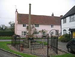 Ripple Cross and Stocks |
|
 Ripple |
|
| Population | 1,779 |
|---|---|
| OS grid reference | SO874377 |
| Civil parish | Ripple |
| District | Malvern Hills |
| Shire county | Worcestershire |
| Region | West Midlands |
| Country | England |
| Sovereign state | United Kingdom |
| Post town | TEWKESBURY |
| Postcode district | GL20 |
| Police | West Mercia |
| Fire | Hereford and Worcester |
| Ambulance | West Midlands |
| EU Parliament | West Midlands |
| UK Parliament | West Worcestershire |
|
|
Coordinates: 52°02′18″N 2°11′05″W / 52.038228°N 2.184712°W
Ripple is a village and civil parish in the Malvern Hills District in the county of Worcestershire, England. Ripple is one of the most southerly parishes in the county and is situated on the A38 road with the River Severn as its eastern boundary. Together with the villages and hamlets of Ryall, Holly Green, The Grove, Naunton, and Uckinghall, the parish has a combined population of 1,799.[1] Ripple is mentioned in passing in the Doomsday book, under the entry of Upton Upon Severn , as being "also held by the Bishop of Worcester".[2]
Ripple once had a railway station on the Midland Railway (later LMS) branch line from Ashchurch to Great Malvern, which ran via Tewkesbury, Ripple, Upton-upon-Severn and Malvern Wells. This was opened from Ashchurch as far as Tewkesbury on 21 July 1840 and extended to Malvern on 16 May 1864. It was closed beyond Upton on 1 December 1952 and the rest (including Ripple) on 14 August 1961. Ripple station still stands, attractively restored, and is now a private house.
References
- ↑ 2011 UK Census
- ↑ http://www.domesdaybook.co.uk/worcestershire4.html
External links
![]() Media related to Ripple, Worcestershire at Wikimedia Commons
Media related to Ripple, Worcestershire at Wikimedia Commons