Rio Minho (Jamaica)
| Rio Minho | |
|---|---|
 | |
| Origin | Dry Habour Mountains, which forms the Cockpit Countries of Jamaica |
| Mouth | Portland Point in Clarendon |
| Basin countries | Jamaica |
| Length | 92.8 km (57.7 mi) |
| Basin area | 1,700 km2 (660 sq mi) |
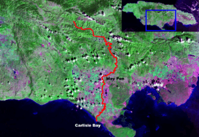
The Rio Minho is the longest river in Jamaica at 92.8 kilometres (57.7 mi).[1] It rises close to the island's geographic centre, flows generally south-southwest and reaches the Caribbean Sea at Carlisle Bay in the central south coast, to the west of the island's southernmost point, Portland Point.
The town of May Pen, Clarendon lies on the banks of the river.