Rio Formoso
| Rio Formoso | |
|---|---|
| Municipality | |
|
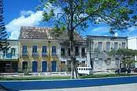
Rio Formoso old Colonial Houses | |
 Rio Formoso Rio Formoso located in Brazil Map | |
| Coordinates: 8°40′S 35°09′W / 8.667°S 35.150°WCoordinates: 8°40′S 35°09′W / 8.667°S 35.150°W | |
| Country |
|
| State | Pernambuco |
| Region | Zona da mata |
| Area | |
| • Total | 239.8 km2 (92.6 sq mi) |
| Elevation | 5 m (16 ft) |
| Population | |
| • Total | 21,815 |
Rio Formoso is a municipality in Pernambuco with 21,815 inhabitants.
Geography
- State - Pernambuco
- Region - Zona da mata Pernambucana
- Boundaries - Sirinhaém (N); Tamandaré (S); Gameleira (W); Tamandaré and Atlantic Ocean (E)
- Area - 239.8 km2
- Elevation - 5 m
- Vegetation - Forest Subperenifólia
- Clima - Hot tropical and humid
- Annual average temperature - 25.2 c
- Distance to Recife - 91 km
Beaches
- Pedra beach and Reduto beach
There are the only two beaches in Rio Formoso. The major attraction is the estuary of the Formoso River. Has an extensive area of coconut trees, sand banks and natural reefs.
Economy
The main economic activities in Rio Formoso are based in food and beverage industry and agribusiness. Especially, coconuts, sugarcane, and creations of cattle.
Economic Indicators
| Population [1] | GDP x(1000 R$).[2] | GDP pc (R$) | PE |
|---|---|---|---|
| 21.815 | 128.391 | 6.107 | 0.21% |
Economy by Sector 2006
| Primary sector | Secondary sector | Service sector |
|---|---|---|
| 11.74% | 40.87% | 47.39% |
Health Indicators
| HDI (2000) | Hospitals (2007) | Hospitals beds (2007) | Children's Mortality every 1000 (2005) |
|---|---|---|---|
| 0.621 | 1 | 65 | 34.1 |
References
- ↑ IBGE Population 2009 Rio Formoso, page 34
- ↑ Rio Formoso 2007 GDP IBGE page 31
- ↑ PE State site - City by city profile