Riera de Merlès
| Merlès | |
|---|---|
|
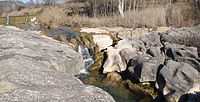
The riera de Merlès in winter, passing through the village of Santa Maria de Merlès | |
| Origin | Rasos de Tubau in Sant Jaume de Frontanyà and Viladonja |
| Mouth |
Llobregat River in Puig-reig 41°55′36.01″N 1°52′55.51″E / 41.9266694°N 1.8820861°ECoordinates: 41°55′36.01″N 1°52′55.51″E / 41.9266694°N 1.8820861°E |
| Basin countries | Spain |
| Source elevation | 1,485 m (4,872 ft)[1] |
| Mouth elevation | 345 m (1,132 ft)[1] |
| Avg. discharge | 0.90 m3/s (32 cu ft/s) [2] |
| Basin area | 173 km2 (67 sq mi)[2] |
| River system | Llobregat |
The Riera de Merlès is a small river that passes through the comarques of Osona, Bages, and Berguedà. It is formed by the confluence of several small mountain creeks and torrents that descend the Rasos de Tubau, in the municipalities of Sant Jaume de Frontanyà and Les Llosses.[2]
Historically, the Merlès marked several administrative frontiers. These include the ancient counties of Berga and Osona, the dioceses of Solsona and Vic, and the modern comarques of Berguedà and Lluçanès.[2]
References
- ↑ 1.0 1.1 "VISSIR3". Mapa Topogràfic de Catalunya (in Catalan). Institut Cartogràfic de Catalunya. Retrieved 23 February 2014.
- ↑ 2.0 2.1 2.2 2.3 "Riera de Merlès". L'Enciclopèdia.cat (in Catalan). Grup Enciclopèdia Catalana. Retrieved 23 February 2014.