Richland Township, Harvey County, Kansas
| Richland Township | |
|---|---|
| Township | |
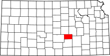
 Location in Harvey County | |
| Coordinates: 37°57′20″N 097°12′26″W / 37.95556°N 97.20722°WCoordinates: 37°57′20″N 097°12′26″W / 37.95556°N 97.20722°W | |
| Country | United States |
| State | Kansas |
| County | Harvey |
| Area | |
| • Total | 36.34 sq mi (94.11 km2) |
| • Land | 36.27 sq mi (93.93 km2) |
| • Water | 0.07 sq mi (0.19 km2) 0.2% |
| Elevation | 1,411 ft (430 m) |
| Population (2000) | |
| • Total | 360 |
| • Density | 9.9/sq mi (3.8/km2) |
| GNIS feature ID | 0473711 |
| Website | County Website |
Richland Township is a township in Harvey County, Kansas, USA. As of the 2000 census, its population was 360.
Geography
Richland Township covers an area of 36.34 square miles (94.1 km2) and contains the ghost town of Annelly and the southeast corner of the unincorporated community of McLain. According to the USGS, it contains one cemetery, Whitewater. The streams of East Branch Whitewater Creek, West Branch Whitewater Creek and West Wildcat Creek run through this township.
Further reading
References
External links
- Harvey County Website
- City-Data.com
- Harvey County Maps: Current, 1941
| |||||||||||||||||||||||||||||