Rhume
| Rhume | |
|---|---|
 | |
| Origin |
Lower Saxony 51°35′23″N 10°18′36″E / 51.58972°N 10.31000°E |
| Mouth |
Leine 51°43′43″N 9°56′52″E / 51.72861°N 9.94778°ECoordinates: 51°43′43″N 9°56′52″E / 51.72861°N 9.94778°E |
| Basin countries | Germany |
| Length | 48 km (30 mi) |
| Source elevation | 160 m (520 ft) |
| Basin area | 1,200 km2 (460 sq mi) |
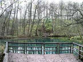
The Rhume is a 48 km long river in Lower Saxony, Germany. It is a right tributary of the Leine. Its source is a karstic spring in Rhumspringe, south of the Harz mountain range. The water drains with high pressure from the ground of the funnel-shaped well, known for its turquoise colour.
The Rhume then flows in northwesterly direction through the municipalities of Gieboldehausen, Katlenburg-Lindau and Northeim. It finally joins the Leine river west of Northeim.