Republic of West Florida
| Republic of West Florida | |||||
| |||||
 | |||||
| Capital | St. Francisville | ||||
| Government | Republic | ||||
| President | Fulwar Skipwith | ||||
| History | |||||
| - | Established | September 23, 1810 | |||
| - | Disestablished | December 10, 1810 | |||
| Today part of | | ||||

The Republic of West Florida was a short-lived, unrecognized republic in the region of West Florida which existed in 1810, and was then was re-incorporated into West Florida.
The United States claimed West Florida as part of the Louisiana Purchase of 1803, a claim disputed by Spain. Spain claimed that West Florida was not part of Louisiana but a part of its Florida colony, and, like the other disputed territory, it had been conquered from England and not received from France. However, before 1762 France had owned the land west of the Perdido River, as part of La Louisiane.
In 1762 France ceded their lands east of the Mississippi River to Great Britain, who in turn gave them back to Spain at the conclusion of the American Revolutionary War. The United States and Spain held long, inconclusive negotiations on the status of West Florida.
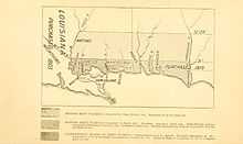
In the meantime, American settlers established a foothold in the area and resisted Spanish control, and the British settlers who had remained after Spanish takeover also resented Spanish rule, leading to a rebellion in 1810 and the establishment of the independent Republic of West Florida, with its capital at St. Francisville, in present-day Louisiana, on a bluff along the Mississippi River.
Boundaries
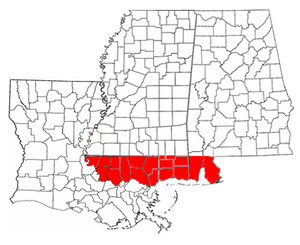
The boundaries of West Florida comprised the territory south of the 31st parallel, west of the Perdido River, and east of the Mississippi River, but north of Lake Pontchartrain. The southern boundary was the Gulf of Mexico. West Florida consisted of the territory called the Baton Rouge district, which lay between the Mississippi and the Pearl rivers; and the Mobile district, which lay between the Pearl and the Perdido.
The Republic of West Florida consisted of the Baton Rouge district.
Despite its name, none of present-day Florida lay within the borders of West Florida. West Florida included present-day Baldwin and Mobile counties in what is now Alabama; the present-day Mississippi counties of Hancock, Pearl River, Harrison, Stone, Jackson, and George, as well as the southernmost portions of Lamar, Forrest, Perry, and Wayne counties; and the present-day Louisiana parishes of East Baton Rouge, East and West Feliciana, Livingston, St. Helena, Tangipahoa, St. Tammany, and Washington.
History
On September 23, 1810, after meetings beginning in June, rebels overcame the Spanish garrison at Baton Rouge and unfurled the flag of the new republic: a single white star on a blue field. This flag was made by Melissa Johnson, wife of Major Isaac Johnson, the commander of the West Florida Dragoons. The "Bonnie Blue Flag" that was flown 50 years later at the start of the American Civil War resembles it.[1]
The Constitution of West Florida was based largely on the United States Constitution, and divided the government into three branches: executive, judicial, and legislative. The legislature consisted of a Senate and House of Representatives. The Governor was chosen by the legislature. According to the constitution, the official name of the country was the "State of Florida". The first and only governor was Fulwar Skipwith, a former American diplomat who had helped negotiate the Louisiana Purchase. In his inaugural address, Skipwith mentioned the possibility of annexation to the United States:
...wherever the voice of justice and humanity can be heard, our declaration, and our just rights will be respected. But the blood which flows in our veins, like the tributary streams which form and sustain the father of rivers, encircling our delightful country, will return if not impeded, to the heart of our parent country. The genius of Washington, the immortal founder of the liberties of America, stimulates that return, and would frown upon our cause, should we attempt to change its course.
Reuben Kemper led a small force in an attempt to capture the Mobile District from the Spanish, but the expedition ended in failure.
United States annexation
The United States did not recognize the independence of the Republic of West Florida, and on October 27, 1810, United States President James Madison proclaimed the possession of West Florida and its annexation into the Territory of Orleans, on the basis that it was part of the Louisiana Purchase.[2] William C. C. Claiborne, the military governor of Orleans Territory, was sent to take possession of the territory.
The West Florida government opposed annexation, preferring to negotiate terms to join the Union. Skipwith proclaimed that he was ready to "die in defense of the Lone Star flag."[3]
Claiborne entered St. Francisville with his forces on December 6, 1810, and Baton Rouge on December 10, 1810. After Claiborne refused to recognize the West Florida government, Skipwith and the legislature eventually agreed to accept Madison's annexation proclamation.
The Mobile District, today's coastal Mississippi and Alabama, remained under Spanish control until the War of 1812 with Britain, with whom Spain was allied. Following a Congressional declaration of annexation in 1812, [4] U.S. General James Wilkinson sailed from New Orleans to Mobile in April 1813 with a force of 600, whereupon he received the surrender of the Spanish commander. The Mobile District was incorporated into the Mississippi Territory.
See also
- List of historical unrecognized states
- West Florida Controversy
- Dominion of British West Florida, 21st-century separatist micronation
References
- ↑ Confederate National and Bonnie Blue Flags.
- ↑ Dreher, Rod (19 June 2012). "West Florida Republic: The birth of US imperialism". BBC News Magazine. BBC. Retrieved 20 June 2012.
- ↑ See inserted "Bonnie Blue Flag" image. The Republic of West Florida was also known as the Lone Star Republic.
- ↑ Tucker, Spencer C. (1993). The Jeffersonian Gunboat Navy. Columbia, SC: University of South Carolina Press. ISBN 0-87249-849-2. p. 101.
Bibliography
- Bice, David A. (2004). The Original Lone Star Republic: Scoundrels, Statesmen & Schemers of the 1810 West Florida Rebellion. Clanton, AL: Heritage Publishing. ISBN 9781891647819.
- Davis, William C. (2011). The Rogue Republic: How Would-Be Patriots Waged the Shortest Revolution in American History. Boston: Houghton Mifflin Harcourt. ISBN 9780151009251.
External links
| Wikisource has original text related to this article: |