Renaud Island
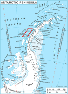 Location of Biscoe Islands in the Antarctic Peninsula region. | |
| Geography | |
|---|---|
| Location | Antarctica |
| Coordinates | 65°40′S 66°00′W / 65.667°S 66.000°W |
| Archipelago | Biscoe Islands |
| Length | 40 km (25 mi) |
| Width | 11 km (7 mi) |
| Country | |
|
None | |
| Demographics | |
| Population | Uninhabited |
| Additional information | |
| Administered under the Antarctic Treaty System | |
Renaud Island is an ice-covered island, 40 km (25 mi) long and from 6.4 to 16.1 km (4 to 10 mi) (average 11.3 km (7 mi)) wide, lying between the Pitt Islands and Rabot Island in the Biscoe Islands of Antarctica. It is separated from Pitt Islands to the northeast by Mraka Sound, and from Lavoisier Island to the southwest by Pendleton Strait.
Coordinates: 65°40′S 66°00′W / 65.667°S 66.000°W
Discovery
The island was first charted and named by the French Antarctic Expedition, 1908–10, under Jean-Baptiste Charcot.
See also
- Composite Antarctic Gazetteer
- List of Antarctic and sub-Antarctic islands
- List of Antarctic islands south of 60° S
- SCAR
- Territorial claims in Antarctica