Remedios T. Romualdez, Agusan del Norte
| Remedios T. Romualdez | ||
|---|---|---|
| Municipality | ||
| ||
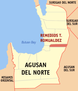 Map of Agusan del Norte with R. T. Romualdez highlighted | ||
.svg.png) R. T. Romualdez Location within the Philippines | ||
| Coordinates: 09°03′13″N 125°35′12″E / 9.05361°N 125.58667°ECoordinates: 09°03′13″N 125°35′12″E / 9.05361°N 125.58667°E | ||
| Country | Philippines | |
| Region | Caraga (Region XIII) | |
| Province | Agusan del Norte | |
| District | 2nd district of Agusan del Norte | |
| Established | January 1, 1984 | |
| Barangays | 8 | |
| Government[1] | ||
| • Mayor | Ernie M. Ceniza | |
| Area[2] | ||
| • Total | 79.15 km2 (30.56 sq mi) | |
| Population (2010)[3] | ||
| • Total | 15,735 | |
| • Density | 200/km2 (510/sq mi) | |
| Time zone | PST (UTC+8) | |
| ZIP code | 8611 | |
| Dialing code | 85 | |
| Income class | 5th | |
| Website |
www | |

Remedios T. Romualdez (formerly Mina–Ano) is a fifth class municipality in the province of Agusan del Norte province, Philippines. According to the 2010 census, it has a population of 15,735 people.[3]
The municipality was incorporated under Batas Pambansa Blg.(Parliamentary Bill No.) 1291 that took effect January 1, 1984. It was named after Remedios Trinidad Romualdez, mother of former First Lady Imelda Romualdez Marcos and is composed of barangays formerly part of the Municipality of Cabadbaran. It is composed of barangays Agay, Basilisa, Balangbalang, Humilog, Panaytayon, San Antonio, and Tagbongabong, all which were previously a and the primary suppliers of agricultural products, notably rice. They are appropriately named the Rice Granary of Cabadbaran. It is one of the leading rice producers of Agusan del Norte province.
It is situated along the Maharlika Highway (the National Highway), it is a halfway town between the Butuan City and Cabadbaran later. Its land area is 8,147 hectares, and is bounded to the north by Cabadbaran, Agusan del Norte; to the south, Butuan City, to the east by Sibagat, Agusan del Sur; and to the west, by Magallanes.
Barangays
Remedios T. Romualdez is politically subdivided into 8 barangays.[2]
- Poblacion I (Agay)
- Balangbalang
- Basilisa
- Humilog
- Panaytayon
- San Antonio
- Tagbongabong
- Poblacion II
Demographics
| Population census of Remedios T. Romualdez | ||
|---|---|---|
| Year | Pop. | ±% p.a. |
| 1990 | 10,490 | — |
| 1995 | 12,621 | +3.53% |
| 2000 | 13,359 | +1.23% |
| 2007 | 14,976 | +1.59% |
| 2010 | 15,735 | +1.82% |
| Source: National Statistics Office[3] | ||
References
- ↑ "Official City/Municipal 2013 Election Results". Intramuros, Manila, Philippines: Commission on Elections (COMELEC). 1 July 2013. Retrieved 5 September 2013.
- ↑ 2.0 2.1 "Province: AGUSAN DEL NORTE". PSGC Interactive. Makati City, Philippines: National Statistical Coordination Board. Retrieved 7 April 2014.
- ↑ 3.0 3.1 3.2 "Total Population by Province, City, Municipality and Barangay: as of May 1, 2010". 2010 Census of Population and Housing. National Statistics Office. Retrieved 1 April 2014.
External links
- Philippine Standard Geographic Code info for RTR
- Official WebSite of the Municipality of Remedios T. Romualdez
- Official Municipality Map of RTR
 |
Cabadbaran | | ||
| Magallanes | |
Sibagat, Agusan del Sur | ||
| ||||
| | ||||
| Butuan |
| ||||||||||||||||||