Reine
| Reine | |
|---|---|
| Village | |
|
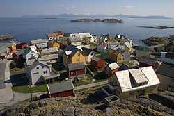
View of the village | |
 Reine Location in Nordland | |
| Coordinates: 67°55′56″N 13°05′22″E / 67.93222°N 13.08944°ECoordinates: 67°55′56″N 13°05′22″E / 67.93222°N 13.08944°E | |
| Country | Norway |
| Region | Northern Norway |
| County | Nordland |
| District | Lofoten |
| Municipality | Moskenes |
| Area[1] | |
| • Total | 0.29 km2 (0.11 sq mi) |
| Elevation[2] | 11 m (36 ft) |
| Population (2013)[1] | |
| • Total | 307 |
| • Density | 1,059/km2 (2,740/sq mi) |
| Time zone | CET (UTC+01:00) |
| • Summer (DST) | CEST (UTC+02:00) |
| Post Code | 8680 Trofors |
Reine is a fishing village and the administrative centre of the municipality of Moskenes in Nordland county, Norway. It is located on the island of Moskenesøya in the Lofoten archipelago, above the Arctic Circle, about 300 kilometres (190 mi) southwest of the town of Tromsø. The 0.29-square-kilometre (72-acre) village has a population (2013) of 307. The population density is 1,059 inhabitants per square kilometre (2,740/sq mi).[1] Reine Church is located here and it serves the northern part of the municipality.
Overview
Reine has been a commercial centre since 1743. Today tourism is important, and despite its remote location, many thousands of people visit annually. The village is situated on a promontory just off the European route E10 highway, which passes through the village. Reine is located immediately to the south of Sakrisoya and Hamnøya.[3]
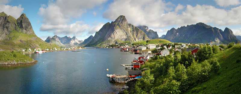
The largest weekly magazine in Norway (Allers) selected Reine as the most beautiful village in Norway in the late 1970s. A photograph over Reine from the mountain Reinebringen has been used for the front page of several tourist brochures and books.
Reine was recently the site of a Coca-Cola launch, referred to by the company as "our smallest launch yet".[4]
Gallery
-

Reine in 2005
-

Reine seen from Reinebringen
-

Reine at night (midnight sun)
-

The fishing fleet at Reine, Gunnar Berg (1863–93)
-

View of Reine in March 2011
-
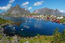
View of Reine
References
- ↑ 1.0 1.1 1.2 Statistisk sentralbyrå (1 January 2013). "Urban settlements. Population and area, by municipality.".
- ↑ "Reine" (in Norwegian). yr.no. Retrieved 2012-06-13.
- ↑ Store norske leksikon. "Reine" (in Norwegian). Retrieved 2012-06-13.
- ↑ https://smallestlaunch.wordpress.com/
External links
| Wikimedia Commons has media related to Reine. |
- Reine, Moskenes (Nordland) Weather Forecast