Reißeck
| Reißeck | ||
|---|---|---|
| ||
 Reißeck Location within Austria | ||
| Coordinates: 46°53′N 13°18′E / 46.883°N 13.300°ECoordinates: 46°53′N 13°18′E / 46.883°N 13.300°E | ||
| Country | Austria | |
| State | Carinthia | |
| District | Spittal an der Drau | |
| Government | ||
| • Mayor | Gerd Pichler | |
| Area | ||
| • Total | 139.83 km2 (53.99 sq mi) | |
| Elevation | 613 m (2,011 ft) | |
| Population (1 January 2014)[1] | ||
| • Total | 2,213 | |
| • Density | 16/km2 (41/sq mi) | |
| Time zone | CET (UTC+1) | |
| • Summer (DST) | CEST (UTC+2) | |
| Postal codes | 9815, 9816 | |
| Area code | 04783 | |
| Website | www.reisseck.at | |

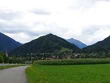
Reißeck is a municipality in the district of Spittal an der Drau in Carinthia in Austria. Situated within the valley of the Möll River, a tributary to the Drava, Reißeck consists of the four Katastralgemeinden Kolbnitz, Zandlach, Penk and Teuchl. The commune was established in 1973 and named after the northern Reißeck mountain (2,965m/9,727 ft), a part of the Hohe Tauern range like the Kreuzeck Group in the south.
Kolbnitz
Kolbnitz is a village in Reißeck at the centre of the Mölltal valley, equidistant between the ski resorts of Ankogel / Mölltaler Glacier and Lake Millstat, often it is known as the 'Heart of Carinthia'. Facilities in Kolbnitz include a rafting centre, a riding centre, tennis courts, a small ski area and a swimming pool. Two funicular railway lines leave from Kolbnitz. The first runs up the Reißeck mountain to an altitude of 2236m/7336 ft to walking trails and a hotel, the second leads to the mountain rail station of "Kreuzeck" at 1211m/3973 ft, which is the starting point for five different alpine walks with an altitude of up to 2498m/8195 ft.
Danielsberg
The cone shaped 966 m (3170 ft) Danielsberg west of Kolbnitz had been a settlement area since the days of the Stone Age. Archaeological artifacts found near the water well at the summit indicate the existence of a Celtic sacred grove and a Roman temple. An Early Christian church dedicated to prophet Daniel was probably erected about 313.
After Bishop Modestus had Christianized the area again in the 8th century, a new church was built at the summit in 1172. It was first mentioned as monte sancti Danielis in a 1252 deed at the occasion of Count Meinhard I of Gorizia-Tyrol's unsuccessful campaign against Duke Bernhard von Spanheim. The church was enlarged in 1515 and a steeple attached in 1750. Beneath the church is the Herkuleshof, now a hotel, erected in 1908.
Transportation
Reißeck can be reached via the B106 Mölltal Straße highway from Lurnfeld in the Drava valley to Obervellach and the Tauern Rail Tunnel. It also has access to the Tauernbahn railway line from Spittal an der Drau to Schwarzach im Pongau at the stations Kolbnitz and Penk.
Infrastructure
Reißeck has two hydroelectric power plants (Kraftwerk Kolbnitz and Kraftwerk Rottau) run by the Verbund power company. The water is collected in several reservoirs at the Reißeck and Kreuzeck mountains as well as in the northern Malta valley and lead to the plant through five penstocks with a maximum altitude difference of about 1772m/5815 ft. Seven (Kraftwerk Kolbnitz) resp. four (Kraftwerk Rottau) Pelton wheels, generating a maximum electric power of 138 to 220 Megawatt each, provide an overall annual electricity production of 1013 mio Kilowatt hours.
Twin towns
References
External links
- "Kar - Music theatre for the mountain" a project of the "Österreichische Draukraftwerke" and ARBOS - Company for Music and Theatre

Wikimedia Commons has media related to Reißeck.