Rehoboth Village Historic District
|
Rehoboth Village Historic District | |
 | |
 | |
| Location | Rehoboth, Massachusetts |
|---|---|
| Coordinates | 41°50′26″N 71°15′9″W / 41.84056°N 71.25250°WCoordinates: 41°50′26″N 71°15′9″W / 41.84056°N 71.25250°W |
| Area | 12 acres (4.9 ha) |
| Built | 1700 |
| Architectural style | Late 19th and 20th Century Revivals, Greek Revival, Late Victorian |
| Governing body | Private |
| MPS | Rehoboth MRA |
| NRHP Reference # |
83000707 [1] |
| Added to NRHP | June 6, 1983 |
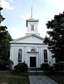
The Rehoboth Village Historic District is a historic district encompassing the historic rural village center of Rehoboth, Massachusetts. The village grew around an industrial site located on the Palmer River, whose waters powered several mills nearby. A modest rural village grew in the area between about 1750 and 1850, with the current church being built in 1839. Later in the 19th century institutional buildings, including Goff Hall and Blanding Library, were added. The village is centered at the junction of Bay State Road and Locust Street.[2]
The district was listed on the National Register of Historic Places in 1983.[1]
Gallery
-
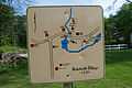
Sign outlining part of the historic district
-
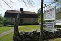
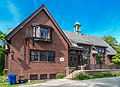
Carpenter Museum at 4 Locust Street
-
Goff Memorial Hall and Blanding Library
See also
References
- ↑ 1.0 1.1 "National Register Information System". National Register of Historic Places. National Park Service. 2008-04-15.
- ↑ "NRHP nomination for Rehoboth Village Historic District". Commonwealth of Massachusetts. Retrieved 2014-06-24.
| |||||||||||||||||||||||||||||||||||||||||||||||||||||||
