Rehaniya
| Rehaniya | |
|---|---|
| Hebrew transcription(s) | |
| • Hebrew | רִיחָאנִיָּה |
| Arabic transcription(s) | |
| • Arabic | الريحانية |
 | |
 Rehaniya Location within Israel's North District | |
| Coordinates: 33°2′54.12″N 35°29′15.36″E / 33.0483667°N 35.4876000°ECoordinates: 33°2′54.12″N 35°29′15.36″E / 33.0483667°N 35.4876000°E | |
| District | Northern |
| Founded | 1878 |
| Government | |
| • Type | Local council |
| Population (2011) | |
| • Total | 1,123 |
| Name meaning | myrtle |
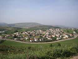
Rehaniya (Adyghe: Рихьаные; Arabic: الريحانية; Hebrew: רִיחָנִיָּה; [rəjħaːnəja]) is a predominantly Circassian village about 8 km north of Safed in northern Israel. It belongs to the Merom HaGalil Regional Council.
Background and history
The Circassians arrived in the Middle East after they were pushed out of their homeland in the North Caucasus. The Circassians, who fought during the long period wherein the Russians captured the northern Caucasus, were massacred and expelled by Tsarist Russia from the Caucasus in an incident that became known as the Circassian Holocaust. The Ottoman Empire absorbed them in their territory and settled them in sparsely populated areas, including the Galilee in Beirut Vilayet (Ottoman Syria).
The area where they settled was called Burak Alma; ("Pools of Alma").[1]
The village Rehaniya was established in 1873, but only in 1878 did Circassian families arrive from the Abazah tribe in the northern Caucasus, a region where today is located the Adygea and Karachay–Cherkessia in the Russian Federation.
In the 1922 census of Palestine conducted by the British Mandate authorities, Rihania had a population of 211; all Muslims,[2] increasing slightly in the 1931 census to 222, still all Muslims, in a total of 53 houses.[3]
In 1945, the population was 290, and the total land area was 6,137 dunums.[4] All the villagers were Muslim.[5] 271 dunums of land were irrigated or used for orchards; 4,725 dunums were allocated to cereal farming,[6] while 89 dunams were built up (urban) land.[7]
The village was built in the traditional Circassian style, which has its roots in the Caucasus, and is called "walled village": the houses are built next to one another and form a protective wall around the city, whose remnants remain until 2008. In the village there is a mosque in the style of Circassian mosques in the Caucasus, and substantially different from Arab mosques. Also, the village contains a museum and a center for Circassian heritage.
In 1948, during Operation Hiram (October 29–31), the villagers surrendered to the advancing Israeli army and were allowed to remain in the village. In November 1949 a plan to evict the villagers, as well as those from five other villages along the border with Lebanon, was presented to the Israeli cabinet. The proposals were strongly supported by the IDF but the plan was vetoed by the Foreign Ministry who were worried about the possible international response.[8] The village remained under Martial Law until 1966.
Rehaniya is one of two predominantly-Circassian villages in Israel. The other one is Kfar Kama, which was recognized as a local council in 1950.
See also
References
- ↑ Palmer, 1881, p. 70
- ↑ Barron, 1923, Table XI, Sub-district of Safad, p. 41
- ↑ Mills, 1932, p. 109
- ↑ Government of Palestine, Department of Statistics. Village Statistics, April, 1945. Quoted in Hadawi, 1970, p. 71
- ↑ United Nations Conciliation Commission for Palestine, Village Statistics, April 1945, p. 5
- ↑ Government of Palestine, Department of Statistics. Village Statistics, April, 1945. Quoted in Hadawi, 1970, p. 120
- ↑ Government of Palestine, Department of Statistics. Village Statistics, April, 1945. Quoted in Hadawi, 1970, p. 170
- ↑ Morris, 1987, pp.226,242,251.
Bibliography
| Wikimedia Commons has media related to Rehaniya. |
- Barron, J. B., ed. (1923). Palestine: Report and General Abstracts of the Census of 1922. Government of Palestine.
- Hadawi, Sami (1970). "Village Statistics of 1945: A Classification of Land and Area ownership in Palestine". Palestine Liberation Organization Research Center.
- Mills, E., ed. (1932). Census of Palestine 1931. Population of Villages, Towns and Administrative Areas. Jerusalem: Government of Palestine.
- Morris, Benny (1987). The Birth of the Palestinian refugee problem, 1947-1949. Cambridge University Press. ISBN 0-521-33028-9.
- Palmer, E. H. (1881). The Survey of Western Palestine: Arabic and English Name Lists Collected During the Survey by Lieutenants Conder and Kitchener, R. E. Transliterated and Explained by E.H. Palmer. Committee of the Palestine Exploration Fund.
External links
- Welcome To Rihaniya
- SWP map IV, IAA
- SWP map 4, Wikimedia commons
- The Circassians in Israel
- Muslim revivalism and the emergence of civic society. A case study of an Israeli-Circassian community
| ||||||||||||||||||