Regions of Singapore
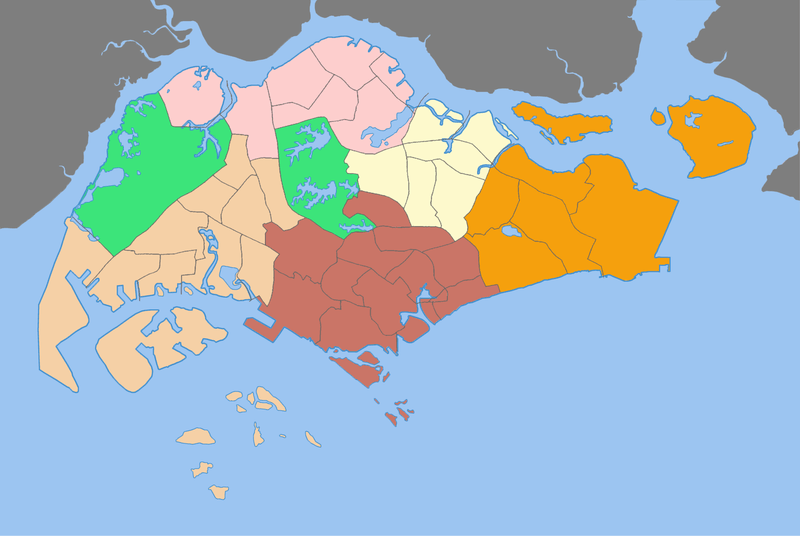
The regions of Singapore are urban planning subdivisions demarcated by the Urban Redevelopment Authority of Singapore to aid in its planning efforts. Over time, however, these 5 regions have also been adopted by other governmental organisations in their administrative work, such as their usage in the census of 2000 by the Department of Statistics. The regions are further subdivided into 55 urban planning areas, which include two water catchment areas.
While utilised by some governmental organizations, these regions are not administrative subdivisions. For administrative purposes, Singapore is divided into five districts and further divided into divisions governed by councils and headed by mayors. These subdivisions are incompatible with the regions subdivisions. The regions are fixed over time while the districts fluctuate with electoral redistricting.
| Region[1] | Largest Town | Area (km²) | Population 2006-06-30 1) | Population Density | Urban Planning Areas |
|---|---|---|---|---|---|
| Central Region | Bukit Merah | 132.7 | 903,100 | 6805 | 22 |
| East Region | Bedok | 93.1 | 673,600 | 7235 | 6 |
| North Region 2) | Woodlands | 97.3 | 472,000 | 4851 | 8 |
| North-East Region | Hougang | 141.1 | 696,900 | 4939 | 7 |
| West Region 3) | Jurong West | 201.3 | 851,000 | 4228 | 12 |
| Singapore | Bedok | 704.0 | 3,600,900 | 5115 | 55 |
| 1) resident population | |||||
| 2) including Central Water Catchment | |||||
| 3) including Western Water Catchment | |||||
References
- ↑ with data from Singapore Department of Statistics at http://www.citypopulation.de/Singapore_d.html
See also
- Urban_planning_areas_in_Singapore
- Subdivisions of Singapore
- Singapore Regions for Housing