Regions of Ivory Coast
 |
| This article is part of a series on the politics and government of Ivory Coast |
|
| Recent history |
|
|
Politics portal |
The regions of Ivory Coast (French: régions de Côte d'Ivoire) are the second-level subdivisions of Ivory Coast (Côte d'Ivoire), after the districts. The fourteen districts (of which two autonomous) and thirty-one regions are listed below,[1] with their populations at the 15 May 2014 Census (provisional results).[2]
| District | District capital | Region | Regional capital | Population Census 2014 |
|---|---|---|---|---|
| Abidjan (autonomous city) |
— | — | — | 4,707,404 |
| Yamoussoukro (autonomous city) | — | — | — | 355,573 |
| Lacs | Dimbokro | N’zi | Dimbokro | 247,578 |
| Iffou | Daoukro | 311,642 | ||
| Bélier | Toumodi | 346,768 | ||
| Moronou | Bongouanou | 352,616 | ||
| Comoé | Abengourou | Indénié-Djuablin | Abengourou | 560,432 |
| Sud-Comoé | Aboisso | 642,620 | ||
| Denguélé | Odienné | Folon | Minignan | 96,415 |
| Kabadougou | Odienné | 193,364 | ||
| Gôh-Djiboua | Gagnoa | Gôh | Gagnoa | 876,117 |
| Lôh-Djiboua | Divo | 729,169 | ||
| Lagunes | Dabou | Agnéby-Tiassa | Agboville | 606,852 |
| Mé | Adzopé | 514,700 | ||
| Grands Ponts | Dabou | 356,495 | ||
| Montagnes | Man | Tonkpi | Man | 992,564 |
| Cavally | Guiglo | 459,964 | ||
| Guémon | Duékoué | 919,392 | ||
| Sassandra-Marahoué | Daloa | Haut-Sassandra | Daloa | 1,430,960 |
| Marahoué | Bouaflé | 862,344 | ||
| Savanes | Korhogo | Poro | Korhogo | 763,852 |
| Tchologo | Ferkessédougou | 467,958 | ||
| Bagoué | Boundiali | 375,687 | ||
| Bas-Sassandra | San-Pédro | Nawa | Soubré | 1,053,084 |
| San-Pédro | San-Pédro | 826,666 | ||
| Gbôklé | Sassandra | 400,798 | ||
| Vallée du Bandama | Bouaké | Hambol | Katiola | 429,977 |
| Gbêkê | Bouaké | 1,010,849 | ||
| Woroba | Séguéla | Béré | Mankono | 389,758 |
| Bafing | Touba | 183,047 | ||
| Worodougou | Séguéla | 272,334 | ||
| Zanzan | Bondoukou | Bounkani | Bouna | 267,167 |
| Gontougo | Bondoukou | 667,185 |
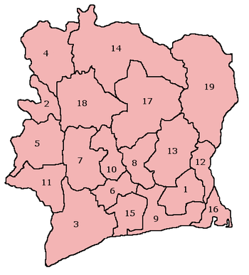
Regions before 2011
 |
Before a reorganization in 2011, the regions were the first-level subdivisions of Ivory Coast. The nineteen regions then in existence (there are now 31, as listed above) were as follows:[3]
- Agnéby
- Bafing
- Bas-Sassandra
- Denguélé
- Dix-Huit Montagnes
- Fromager
- Haut-Sassandra
- Lacs
- Lagunes
- Marahoué
- Moyen-Cavally
- Moyen-Comoé
- N'zi-Comoé
- Savanes
- Sud-Bandama
- Sud-Comoé
- Vallée du Bandama
- Worodougou
- Zanzan
The regions were further divided into departments.
See also
References
- ↑ Districts of Côte d'Ivoire at statoids.com
- ↑ Institut National de la Statistique, Cote d'Ivoire.
- ↑ Regions of Côte d'Ivoire at statoids.com
| ||||||||||