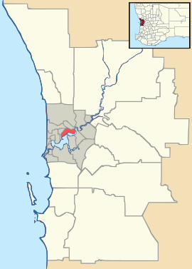
Redcliffe, Western Australia
| Redcliffe Perth, Western Australia | |||||||||||||
|---|---|---|---|---|---|---|---|---|---|---|---|---|---|
 Redcliffe | |||||||||||||
| Coordinates | 31°56′17″S 115°56′24″E / 31.938°S 115.940°ECoordinates: 31°56′17″S 115°56′24″E / 31.938°S 115.940°E | ||||||||||||
| Population | 4,280 (2006 census)[1] | ||||||||||||
| Postcode(s) | 6104 | ||||||||||||
| LGA(s) | City of Belmont | ||||||||||||
| State electorate(s) | Belmont | ||||||||||||
| Federal Division(s) | Swan | ||||||||||||
| |||||||||||||
Redcliffe is a suburb of Perth and is located within the City of Belmont local government area.
The boundaries of the suburb are determined by the Great Eastern Highway, Tonkin Highway and Epsom Avenue, Belmont, and the grounds of the Perth International Airport which lie on the eastern edge of the suburb.[2]
The story of its name is ambiguous: while some claim it was named after steep red clay deposits that lined the banks of the Swan River when settlers first arrived, others claim that it was named after the ancestorial home of an early settler. The suburb was once a single property near modern-day Water Street and the main house, 'Nulsen Haven' still stands today. The local Primary school was built in 1908 and at this time, Redcliffe had been transformed from one property into many small farms after being subdivided in 1897.
Modern Redcliffe is a mix of residential, semi-industrial and retail buildings. It is 18 minutes from the Perth CBD and a short walk from the Swan River.
Redcliffe is scheduled to gain a railway station in 2020, when Airport West opens as part of the Forrestfield-Airport Link.[3]
References
- ↑ Australian Bureau of Statistics (25 October 2007). "Redcliffe (State Suburb)". 2006 Census QuickStats. Retrieved 2008-10-05.
- ↑ In road-maps of post 2012, the airport is located in its own locality - Perth, Airport with a post code of 6105 - see maps 345 and 375 of Greater Perth street directory (54th ed ed.), Ausway Digital, 2012, retrieved 12 March 2015
- ↑ Forrestfield-Airport Link Public Transport Authority August 2014