Red Lake (Romania)
For Lacu Roșu village in Harghita County, see Gheorgheni.
| Lacul Roșu | |
|---|---|
 | |
| Location | Eastern Carpathians |
| Coordinates | 46°47′22″N 25°47′13″E / 46.78931°N 25.7869°ECoordinates: 46°47′22″N 25°47′13″E / 46.78931°N 25.7869°E |
| Basin countries | Romania |
| Max. length | 8 kilometres (5.0 mi) |
| Max. width | 300 metres (980 ft) |
| Surface area | 11.47 hectares (28.3 acres) |
| Average depth | 9,7 m |
| Max. depth | 12.5 metres (41 ft) |
| Water volume | 587,500 cubic metres (20,750,000 cu ft) |
| Surface elevation | 983 metres (3,225 ft) |

Red Lake 3D
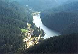
Lacul Roșu (Romanian: Lacul Roșu, Hungarian: Gyilkos-tó) is a barrier lake in the Eastern Carpathians chain in Harghita County, Romania. The name of "Lacul Roșu" comes from the reddish alluvia deposited in the lake by the Red Creek. The lake falls within the jurisdiction of the municipality of Gheorgheni.

See also
- Bicaz Canyon
- Cheile Bicazului-Hășmaș National Park
External links
![]() Media related to Lacul Roşu at Wikimedia Commons
Media related to Lacul Roşu at Wikimedia Commons