Red Lake, Minnesota
| Red Lake, Minnesota | |
|---|---|
| CDP | |
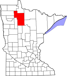
 Location of Red Lake in Beltrami County and Minnesota | |
| Coordinates: 47°52′38″N 95°0′44″W / 47.87722°N 95.01222°W | |
| Country | United States |
| State | Minnesota |
| County | Beltrami |
| Area | |
| • Total | 5.1 sq mi (13.1 km2) |
| • Land | 4.8 sq mi (12.5 km2) |
| • Water | 0.2 sq mi (0.6 km2) |
| Elevation | 1,211 ft (369 m) |
| Population (2010) | |
| • Total | 1,731 |
| • Density | 340/sq mi (130/km2) |
| Time zone | Central (CST) (UTC-6) |
| • Summer (DST) | CDT (UTC-5) |
| ZIP code | 56671 |
| Area code(s) | 218 |
| FIPS code | 27-53458[1] |
| GNIS feature ID | 0649864[2] |
Red Lake is a census-designated place (CDP) within the Lower Red Lake unorganized territory located in Beltrami County, Minnesota, United States. As of the 2010 census, Red Lake had a total population of 1,731.[3] The Red Lake Indian Reservation is based in Red Lake.
History
2005 shooting
On March 21, 2005, the town was the scene of the Red Lake massacre. Jeff Weise, a 16-year-old Ojibwe high school student, murdered his grandfather and his girlfriend with a Ruger .22-caliber pistol at his trailer home, drove to the senior high school in Red Lake, and murdered a security guard, a schoolteacher, and five students with a Remington 12-gauge shotgun. The shooting ended when Weise committed suicide. The community has since struggled, which separated families and challenged the faith of many. [4]
Geography
According to the United States Census Bureau, the CDP has a total area of 5.1 mi² (13.1 km²), of which 4.8 mi² (12.5 km²) is land and 0.2 mi² (0.6 km²), 4.70%, is water.
Demographics
As of the census[1] of 2000, there were 1,430 people, 400 households, and 320 families residing in the CDP. The population density was 110.2/mi² (42.5/km²). There were 421 housing units at an average density of 32.4² (12.5/km(). The racial makeup of the CDP was 97.69% Native American, 1.82% White, 0.28% Black or African American, 0.07% from other races, and 0.14% from two or more races. Hispanic or Latino of any race were 1.47% of the population.
There were 400 households out of which 49.0% had children under the age of 18 living with them, 24.5% were married couples living together, 42.0% had a female householder with no husband present, and 20.0% were non-families. 18.3% of all households were made up of individuals and 4.3% had someone living alone who was 65 years of age or older. The average household size was 3.53 and the average family size was 3.88.
In the CDP the population was spread out with 44.1% under the age of 18, 12.0% from 18 to 24, 24.1% from 25 to 44, 15.6% from 45 to 64, and 4.3% who were 65 years of age or older. The median age was 21 years. For every 100 females there were 94.0 males. For every 100 females age 18 and over, there were 84.3 males.
The median income for a household was $23,224, and the median income for a family was $20,800. Males had a median income of $22,257 versus $22,431 for females. The per capita income for the CDP was $8,787. About 36.8% of families and 36.4% of the population were below the poverty line, including 42.8% of those under the age of 18 and 44.4% of those 65 and older.
It has also in recent years become a bastion for illegal immigrants, as well as a recent influx of former off-reservation residents return due to a ripple effect of the recent economic downturn. The number of people residing (Legally, or Illegally) within the confines of the Reserve is estimated to be closer to 10,000.
Education
Red Lake School District operates public schools.
External links
References
- ↑ 1.0 1.1 "American FactFinder". United States Census Bureau. Retrieved 2008-01-31.
- ↑ "US Board on Geographic Names". United States Geological Survey. 2007-10-25. Retrieved 2008-01-31.
- ↑ "American FactFinder". United States Census Bureau. Retrieved 2011-05-14.
- ↑ Ten dead in US school shooting | Special reports | Guardian Unlimited
| |||||||||||||||||||||||||||||||||||||
Coordinates: 47°52′35″N 95°01′01″W / 47.87639°N 95.01694°W
