Red Crane, Portland

Red Crane is a crane on the Isle of Portland, Dorset, England. It is situated on the cliff edge at Portland's southerly point, the promontory Portland Bill. The crane is part of the now-disused Portland Bill stone loading quay, which has become a scheduled monument under the Ancient Monuments and Archaeological Areas Act 1979, because it appears to the Secretary of State to be of national importance.[1]
History

The area of Portland Bill was used for quarrying across the cliff edges from the 19th century or earlier, and this operation continued until the early 20th century. During its commercial years, stone shipping quays were created to transport the stone off the island. With the establishment of the stone industry, quarry owners were given the right to erect piers with cranes for shipping stone from anywhere along the coastline. The majority of piers were on the eastern side of the island such as King's Pier, Durdle Pier, and three piers around Church Ope Cove amongst others. However there were also some piers at West Weares, the western side of the island, but these would only be in brief use due to the unstable nature of the coastline, as well as a lack of roads.[2]
The hand-operated wooden crane known locally as Red Crane was originally designed for the same purpose, and after quarrying ceased in the area at the into the 20th century, Red Crane was mainly used to lower fisherman and their boats into the sea. The crane was later replaced by a steel crane, which has remained standing ever since. It continues to be used by fishermen, whilst the site has also become a popular spot for memorial plaques to loved ones who had an affection of the spot.[3] As part of Portland Bill, the site has become a popular tourist attraction within the area, and is often photographed. Next to the crane, coastal erosion has widened a joint/fissure within the cliff edge. At high tide during major storms, waves surge into this fissure, trapping compressed air ahead and this immediately blasts out the top of the narrow slit as a blowhole. Although mostly inactive, this only occurs during large storms.[4]
Within the southernmost area of the Bill, there is still evidence of quarrying tramways. The storms of January 1990 ripped out an area of cliff top to reveal old rails from the Victorian tramway where it curved round to meet the crane.[3] A similar crane, also steel, is the Broad Ope Crane (also known as Bob's Crane), and this one is located further east of Portland Bill, near Cave Hole.[4] An original wooden crane exists further along the east of the island, named Sandholes Crane. Red Crane is the nearest to Portland Bill's southern-most point. A similar wooden crane, which was also used by fishermen after quarrying ceased, was located at Durdle Pier, even further beyond that. However the storms of early January 2014 destroyed this crane.[5]
References
- ↑ "1002388 - The National Heritage List for England | English Heritage". List.english-heritage.org.uk. Retrieved 2014-02-10.
- ↑ Morris, Stuart (1985). Portland: An Illustrated History. Dovecote Press. p. 54. ISBN 978-0946159345.
- ↑ 3.0 3.1 "Portland Bill, Portland, Dorset". Geoffkirby.co.uk. Retrieved 2014-02-10.
- ↑ 4.0 4.1 "Portland Bill - Geological Field Guide". Southampton.ac.uk. Retrieved 2014-02-10.
- ↑ "Detailed Result: Durdle Pier". Pastscape. Retrieved 2014-02-10.
Gallery
-

Red Crane
-

Red Crane with Portland Bill Lighthouse in the background.
-

Red Crane during Storm St Jude of 2013.
-
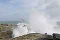
Red Crane's active Blow Hole during Storm St Jude of 2013.
Coordinates: 50°30′55″N 2°27′11″W / 50.5152°N 2.4531°W
| ||||||||||||||||||||||||||||||||||||||||||||||||||||||||||||||||||