Ray Township, Franklin County, Indiana
| Ray Township | |
|---|---|
| Township | |
|
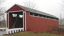
Stockheughter Covered Bridge | |
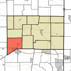 Location of Ray Township in Franklin County | |
| Coordinates: 39°19′40″N 85°14′30″W / 39.32778°N 85.24167°WCoordinates: 39°19′40″N 85°14′30″W / 39.32778°N 85.24167°W | |
| Country | United States |
| State | Indiana |
| County | Franklin |
| Government | |
| • Type | Indiana township |
| Area | |
| • Total | 39.69 sq mi (102.8 km2) |
| • Land | 39.61 sq mi (102.6 km2) |
| • Water | 0.08 sq mi (0.2 km2) |
| Elevation[1] | 958 ft (292 m) |
| Population (2010) | |
| • Total | 4,021 |
| • Density | 101.5/sq mi (39.2/km2) |
| FIPS code | 18-63126[2] |
| GNIS feature ID | 453782 |
Ray Township is one of thirteen townships in Franklin County, Indiana. As of the 2010 census, its population was 4,021.[3]
History
Ray Township is named for James B. Ray, fourth Governor of Indiana.[4]
Geography
According to the 2010 census, the township has a total area of 39.69 square miles (102.8 km2), of which 39.61 square miles (102.6 km2) (or 99.80%) is land and 0.08 square miles (0.21 km2) (or 0.20%) is water.[3]
Cities and towns
- Batesville (north quarter)
- Oldenburg
Unincorporated towns
(This list is based on USGS data and may include former settlements.)
Adjacent townships
- Salt Creek Township (north)
- Butler Township (east)
- Adams Township, Ripley County (southeast)
- Laughery Township, Ripley County (south)
- Salt Creek Township, Decatur County (west)
- Fugit Township, Decatur County (northwest)
Major highways
Cemeteries
The township contains one cemetery, Holy Family.
References
- ↑ "US Board on Geographic Names". United States Geological Survey. 2007-10-25. Retrieved 2008-01-31.
- ↑ "American FactFinder". United States Census Bureau. Retrieved 2008-01-31.
- ↑ 3.0 3.1 "Population, Housing Units, Area, and Density: 2010 - County -- County Subdivision and Place -- 2010 Census Summary File 1". United States Census. Retrieved 2013-05-10.
- ↑ Reifel, August Jacob (1915). History of Franklin County, Indiana. Windmill Publications. p. 164.
External links
| |||||||||||||||||||||||||||||||||