Rathausbrücke Zürich
| Rathausbrücke | |
|---|---|
 Rathausbrücke and Weinplatz to the left, and Rathaus Zürich in the foreground, as well as Schipfe and Lindenhof hill, as seen from Grossmünster's Karlsturm | |
| Coordinates | 47°22′18″N 8°32′31″E / 47.37167°N 8.54194°ECoordinates: 47°22′18″N 8°32′31″E / 47.37167°N 8.54194°E |
| Carries | pedestrians |
| Crosses | Limmat river |
| Locale | Lindenhof–Schipfe–Weinplatz–Limmatquai in Zürich, Switzerland |
| Official name | Rathausbrücke |
| ID number | 1572 |
| Characteristics | |
| Material | concrete |
| Number of spans | 4 |
| History | |
| Construction begin | 1892 |
| Opened | 1893 |
| Statistics | |
| Daily traffic | pedestrian |
Rathausbrücke is pedestrian bridge and also a public square situated over the Limmat river in the municipality of Zürich in the Canton of Zürich in Switzerland. It is listed in the Swiss inventory of cultural property of national and regional significance.
_-_linkes_Limmatufer_-_Rathausbr%C3%BCcke_-_Weinplatz_2013-04-08_15-15-27.jpg)

Geography
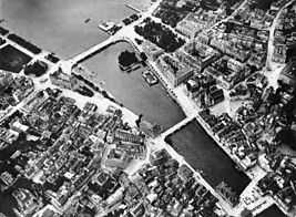
Rathausbrücke is situated in the historical core of the medieval town of Zürich, previously the Celtic-Roman Turicum on the southeasterny foothill of the Celtics Lindenhof-Weinplatz and Münsterhof area, crossing the Limmat river that connecting the historical Schipfe quarter and Limmatquai at the historical core of the medieval town on the western, right hand bank of the Limmat river.
Thus, the historical important bridge of Zürich, it is not a nodal point of the present tram railways, neither of the road traffic between General-Guisan-Quai,[1] Limmatquai, Rämistrasse and Utoquai in the Zürich quarters of Lindenhof and Rathaus.
Transportation
The Zürich tram lines 2, 4 and 15, as well as the Zürichsee-Schiffahrtsgesellschaft (ZSG) and its Limmat river tour boats towards Zürichhorn respectively Landesmuseum provide public transportation. Individual transportation usually is strictly limited, thus the area is part of the pedestrian zone of Zürich respectively limited to road tansport use between lower Limmatquai and Bellevueplatz upstream the Limmat river.
Since 25 September 2004, the driving of motor vehicles, motorcycles and scooters is forbidden, excepted to cargo handling, rides in traffic with the cantonal police station, postal delivery services as well as medical doctors and emergency services.[2]
History
Commonly known as Gmüesbrugg, a Swiss-German term for "vegetable bridge", named after the medieval market there, the former Untere Brücke (lower bridge) is named after the Rathaus that was built between 1692 and 1698. The present construction was built in 1892/93.[3] Today it serves as a public square and part of the pedestrian zone, and Rathausbrücke is place of numerous local festivals and public events.
Weinplatz
The square in front of the lower bridge, thenafter the old Kornhausplatz was in medieval times used as a grain and vegetable, and became in 1630 the public market for local wines, the today's Weinplatz. Despite the relocation of the market to the Munsterhof square in 1647, the name is still the same.[4] Some sources remain Rother Turm meaning red tower, that in the early 13th century was used by the House of Rapperswil as it seats in Zürich; much later it became a 'literature café' and was broken. At the same site there is today the Hotel Storchen, claimed to be one of the finest hotels and bars in Zürich, also used as a guild house. Opposite of the building, the former seat of the medieval Mülner family is located, the so-called Haus zum Schwert, named after the sword holder of the Banner of Zürich.
Not yet archaeological proven but suggested by the historians, Weinplatz was also the former civilian harbour of the Celtic-Roman Turicum, and so the term Weinplatz may hove an ancient meaning.[5]
Cultural Heritage
Rathausbrücke is listed in the Swiss inventory of cultural property of national and regional significance as a Class A object.[6]
References
- ↑ Grün Stadt Zürich (May 2006). "Vom Bürkliplatz zur Sukkulenten-Sammlung" (in German). Grün Stadt Zürich. Retrieved 2015-01-07.
- ↑ "Limmatquai" (in German). Poliezidepartement Stadt Zürich. Retrieved 2015-01-06.
- ↑ Gebrüder Dürst. "Rathausbrücke" (in German). alt-zueri.ch. Retrieved 2015-01-07.
- ↑ Gebrüder Dürst. "Weinplatz" (in German). alt-zueri.ch. Retrieved 2015-01-07.
- ↑ "Turicum II" (in German). Hochbaudepartement Stadt Zürich. Retrieved 2015-01-07.
- ↑ "A-Objekte KGS-Inventar". Schweizerische Eidgenossenschaft, Amt für Bevölkerungsschutz. 2009. Retrieved 2015-01-07.
External links
| Wikimedia Commons has media related to Rathausbrücke Zürich. |