Raschau-Markersbach
| Raschau-Markersbach | |
|---|---|
 Raschau-Markersbach | |
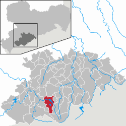
Location of Raschau-Markersbach within Erzgebirgskreis district  | |
| Coordinates: 50°31′56″N 12°52′17″E / 50.53222°N 12.87139°ECoordinates: 50°31′56″N 12°52′17″E / 50.53222°N 12.87139°E | |
| Country | Germany |
| State | Saxony |
| District | Erzgebirgskreis |
| Area | |
| • Total | 39.52 km2 (15.26 sq mi) |
| Population (2013-12-31)[1] | |
| • Total | 5,217 |
| • Density | 130/km2 (340/sq mi) |
| Time zone | CET/CEST (UTC+1/+2) |
| Postal codes | 08352 |
| Dialling codes | 03774 |
| Vehicle registration | ERZ |
| Website | www.markersbach.de |
Raschau-Markersbach is a municipality in the district of Erzgebirgskreis in Saxony, Germany. It was formed on 1 January 2008, by the merger of the former municipalities Markersbach and Raschau.
Gallery
-

Ruins of the lime plant
-

-

-

Looking through the bridge under construction of the bypass stream marker (B101) on the marker Bacher Viaduct
-
Pumped storage plant markers (Bach Dam)
-

Elementary school
-

-

-

References
- ↑ "Statistisches Landesamt des Freistaates Sachsen – Bevölkerung des Freistaates Sachsen jeweils am Monatsende ausgewählter Berichtsmonate nach Gemeinden" (PDF). Statistisches Landesamt des Freistaates Sachsen (in German). 6 September 2014.
| Wikimedia Commons has media related to Raschau-Markersbach. |
