Ranong Province
| Ranong ระนอง | ||
|---|---|---|
| Province | ||
 | ||
| ||
 Map of Thailand highlighting Ranong Province | ||
| Country |
| |
| Capital | Ranong | |
| Government | ||
| • Governor | Wanchat Wongchaichana (since 2008) | |
| Area | ||
| • Total | 3,298.0 km2 (1,273.4 sq mi) | |
| Area rank | Ranked 59th | |
| Population (2014) | ||
| • Total | 177,089 | |
| • Rank | Ranked 76th | |
| • Density | 54/km2 (140/sq mi) | |
| • Density rank | Ranked 71st | |
| Time zone | Thailand Standard Time (UTC+7) | |
| ISO 3166 code | TH-85 | |
Ranong (Thai ระนอง) is one of Thailand's southern provinces (changwat), located on the west coast along the Andaman Sea. It has the fewest inhabitants of any Thai provinces. Neighboring Ranong are (clockwise) Chumphon, Surat Thani and Phang Nga. To the west, it borders Kawthaung, Tanintharyi, Myanmar.
Geography
Ranong is located on the Kra Isthmus, a narrow strip of land that connects Thailand with the Malay Peninsula, on the west of the Phuket mountain range. It has a long coast on the Andaman Sea. The province is known for having the highest rainfall in Thailand, the rainy season there lasting for about eight months. Its annual rainfall in 1955 totaled 6,699.5 mm, compared to about 1,200 in central Thailand.
Ranong is the least populated province; 80% of its area is covered by forests, and 67% is mountainous. In former years the major industry was tin mining, but most mines are now exhausted. White clay mining (for the production of porcelain) and fishing are now the main industries, along with rubber and cashew nuts.
The Ranong Biosphere Reserve in the north of Amphoe Kapoe, covering 303.09 km², was declared in 1997. It is the fourth biosphere reserve of Thailand, and the only one at the seacoast to protect the mangrove forests. Khlong Nakha Wildlife Sanctuary is in the south of the province.
Climate
| Climate data for Ranong (1981–2010) | |||||||||||||
|---|---|---|---|---|---|---|---|---|---|---|---|---|---|
| Month | Jan | Feb | Mar | Apr | May | Jun | Jul | Aug | Sep | Oct | Nov | Dec | Year |
| Average high °C (°F) | 32.8 (91) |
34.1 (93.4) |
35.0 (95) |
34.6 (94.3) |
32.4 (90.3) |
31.2 (88.2) |
30.9 (87.6) |
30.5 (86.9) |
30.5 (86.9) |
31.0 (87.8) |
31.4 (88.5) |
31.7 (89.1) |
32.17 (89.92) |
| Average low °C (°F) | 21.9 (71.4) |
22.2 (72) |
23.4 (74.1) |
24.6 (76.3) |
24.7 (76.5) |
24.5 (76.1) |
24.3 (75.7) |
24.2 (75.6) |
23.9 (75) |
23.6 (74.5) |
23.3 (73.9) |
22.4 (72.3) |
23.58 (74.45) |
| Average rainfall mm (inches) | 10.0 (0.394) |
16.0 (0.63) |
65.2 (2.567) |
152.6 (6.008) |
496.6 (19.551) |
649.4 (25.567) |
620.7 (24.437) |
789.1 (31.067) |
646.5 (25.453) |
424.5 (16.713) |
151.3 (5.957) |
45.5 (1.791) |
4,067.4 (160.135) |
| Avg. rainy days (≥ 1 mm) | 4 | 3 | 5 | 12 | 23 | 26 | 27 | 28 | 26 | 23 | 15 | 7 | 199 |
| Average relative humidity (%) | 72 | 70 | 71 | 76 | 83 | 84 | 85 | 86 | 86 | 85 | 80 | 75 | 79.4 |
| Source: Thai Meteorological Department (Normal 1981-2010), (Avg. rainy days 1961-1990) | |||||||||||||
History
The name Ranong is a Thai corruption of Rundung, (Jawi: روندوڠ),[1] a sparsely populated former Malay principality once under the Malay Sultanate of Kedah. Rundung gradually submitted to Thai rule after repeated Thai invasions during the Ayutthaya period centuries ago.
The Khaw family
The Khaw family is very important in the history of Ranong. Khaw Soo Cheang was a Chinese immigrant from Zhangzhou, Fujian Province. He was an officer of the "Small Knives Secret Society", which was fighting to restore the Ming Dynasty. His other name was Khaw Teng Hai, and his alias was Khaw Soo Cheang. In 1810 he arrived in Penang, staying in Sungai Tiram about 1 kilometer from the present Bayan Lepas International Airport, where he was a small-scale vegetable farmer. Once a week Khaw Soo Cheang took his produce to Jelutong to sell.
Khaw Soo Cheang eventually started a small sundries shop under the name of Koe Guan. He started trading along the coast of southern Thailand.
Khaw Soo Cheang had six sons: Khaw Sim Cheng, Khaw Sim Kong, Khaw Sim Chua, Khaw Sim Khim, Khaw Sim Teik, and Khaw Sim Bee. Sim Cheng is believed to have been born to his China wife. Sim Kong, Sim Chua, Sim Khim and Sim teik were sons of second wife Sit Kim Lean, who is buried in Ranong. The youngest was born one of his numerous Thai minor wives.
Khaw Soo Cheang diversified into tin mining, shipping and hiring immigrant labourers. In 1844, he was appointed the Royal Collector of tin royalties in the Ranong, and receiving the royal title Luang Ratanasethi. In 1854 King Rama IV Mongkut made him governor of Ranong and elevated him to the higher noble rank of Phra. Ranong was then subordinate to Chumphon province, but in 1864 it was elevated to full provincial status. Khaw Soo Cheang thus was raised to be a Phraya. He successfully defended the new province against invasion by Burma, whhich sought to annex it for its tin deposits. The Khaw family became close to the Thai royal court, especially with Prince Damrong Rajanubhab, who stayed at the family's home in Penang, named Chakrabong in honour of the Thai royal family. in 1872, Khaw Soo Cheang, then 81 years old, returned to China where he married an 18-year-old wife. Prior to the voyage he made his will. However, he lived another 10 years.
The eldest son, Khaw Sim Cheng, died before his father. The second son, Khaw Sim Kong, succeeded him as governor of Ranong in 1874. In 1896 Sim Kong became commissioner of the Monthon of Chumphon. His fourth son, Sim Khim, became governor of Kraburi, and the fifth son, Sim Teik, became governor of Langsuan. Khaw Sim Bee, the youngest son, Ratsadanupradit Mahison Phakdi became governor of Trang, and in 1900 was commissioner of Monthon Phuket.
The Khaw family founded a steamship company known as the Eastern Shipping Company. They also formed the Eastern Trading Company which they tried unsuccessfully to list on the stock exchange. Their business empire also included Tongkah Harbour, the first Asian company involved in dredging the harbor floor for tin (a publicly listed company). The Penang branch of the family were also one of the founders of an insurance company known as Khean Guan Insurance .
In his will dated 1872 Khaw Soo Cheang divided his estate into 16 parts, of which 15 parts were distributed to his descendants. One-sixteenth was used to set up Koe Guan Kong Lun, the family trust, which came into existence in 1905. Under the terms of the Trust Deed, 21 years after the death of the last person whose name appeared in the deed thye would be inherit it. The last person was his great-grandson Khaw Bian Ho, who died on October 21, 1972. Twenty-one years later, on October 21, 1993, the Trust was vested, and the Trustees began the process of ending Koe Guan Kong Lun. Khaw Soo Cheang, who gave up his position as Governor of Ranong in 1874, arranged for his second son Khaw Sim Kong to lead the family enterprise in Thailand. His fourth son Khaw Sim Khim took managed and led the family interests in Penang until his death in 1903.
After the death of Khaw Sim Bee in 1913, a commissioner from outside the area was appointed to by the government end the traditionally inherited administrative power of the family. The family essentially divided into the Malaysian and Thai braanches. In 1932 all Chinese immigrants and their descendants had to adopt a Thai family name after the military coup ended the absolute monarchy. The Thai monarch had already bestowed the name Na Ranong ("from Ranong") on Khaw Soo Cheang's descendants in Thailand. In Malaysia and elsewhere they are still known as the Khaw family.
Khaw Soo Cheang, Khaw Sim Kong. Khaw Sim Teik and Khaw Sim Bee's tombs are today located in Ranong. The tombs of Khaw Sim Khim is located in Batu Lanchang Chinese cemetery while Khaw Sim Chua, who had no sons, is purportedly buried off Kampar Road in Penang. Today the male lines of the eldest son Sim Cheng and the third son Sim Chua are extinct.
Today the only vestige of his presence in Penang is the Penang state hall known as Dewan Sri Pinang which sits on the land known as Ranong grounds which was given by the Khaw family to the then government of the day in gratitude for the opportunities. The houses where the Khaw family resided on the famous millionaires' road Northam Road such as Asdang, Chakrabong and the house owned by Khaw Sim Khim opposite the old Shih Chung school besides No 32, have all been sold and demolished and no longer remain in the hands of the family.
Symbols
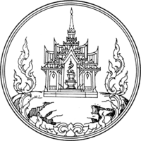
The provincial seal shows a castle on top of a hill, to remember that King Chulalongkorn (Rama V) once visited Ranong and stayed at the Ratana Rangsan Castle on top of the Niveskiri Hill.
The provincial tree is the Banaba (Lagerstroemia speciosa), and the provincial flower is the orchid Dendrobium formosum.
Administrative divisions
Ranong is subdivided into five districts (amphoe). These are further subdivided into 30 subdistricts (tambon) and 167 villages (muban). Ranong itself is the only town (thesaban mueang), and there are five more subdistrict municipalities (thesaban tambon).
| Map | Number | Name | Thai |
|---|---|---|---|
 | |||
| 1 | Mueang Ranong | เมืองระนอง | |
| 2 | La-un | ละอุ่น | |
| 3 | Kapoe | กะเปอร์ | |
| 4 | Kra Buri | กระบุรี | |
| 5 | Suk Samran | สุขสำราญ |
Tourism
Sights
Rattanarangsarn Palace (พระราชวังรัตนรังสรรค์ จำลอง ) ...Phraya Damrong sutjarit Mahitsornpakdee (Kor Sim Kong) built this throne hall for the residence of King Rama V during the royal visit to Ranong Province on April 23–25, 1890. It is located on the hilltop named "Niwest Kiree". But the original throne hall was later dismantled and replaced by the city hall and then the new provincial hall was built in 2002. It was made of teak wood. It is a historical tourist attraction of Ranong residents.
Ranong Governor’s Grave (สุสานเจ้าเมืองระนอง) This Chinese grave of Phraya Rattanasetthi (Kho Su Chiang), Ranong’s first governor, is situated on a piece of land dedicated by King Rama V. There are three tiers of stone platform with steps leading up to the grave with antique granite sculptures of Chinese noblemen, horses, goats and lions on both sides.
Hot Springs and Raksawarin Public Park (บ่อน้ำร้อนและสวนสาธารณะรักษะวาริน) The hot springs have been a popular tourist spot ever since King Rama V visited Ranong in 1890. There are three natural spring pools. The temperature of the water in the pools remains constant at about 65 °C.
Wat Hat Som Paen (วัดหาดส้มแป้น) This temple is on Khlong Hat Som Paen and provides a sanctuary for a shoal of soro brook carp.
Wat suwan Khiri (วัดหน้าเมือง) It contains a Burmese style Chedi, over 70 years old and 10 metres in height, which was built by a Burmese, a main ordination hall or Phra Ubosot where a beautifully bejeweled standing Buddha image is enshrined and a belfry decorated with a feline pattern.
Namtok Punyaban (น้ำตกปุญญบาล) Formerly known as Namtok Set Takuat, this 20-metre high waterfall is located at Mu 1 Tambon Bang Non, on the right at km. 597 on Highway No.4 towards Chumphon.
Namtok Ton Phet (น้ำตกโตนเพชร) Surrounded by moist evergreen forest with Ranong’s highest Phota Chong Dong Mountains being the source of water, each tier of the falls cascades down boulders all year round.
Phukhao Ya (Grass Hill) or Khao Hua Lan (Bald Hill) (ภูเขาหญ้าหรือเขาหัวล้าน) Known to locals by a variety of names and endearingly referred to as Thailand’s version of a Swiss pasture, this hill is something of an anomaly as it is completely treeless, being covered instead by a thick blanket of grass.
Namtok Ngao National Park (อุทยานแห่งชาติน้ำตกหงาว) Covering a total area of approximately 417,500 rai in Amphoe La-un and Amphoe Mueang of Ranong and Amphoe Sawi, Amphoe Thung Tako, Amphoe Lang Suan and Amphoe Phato of Chumphon, it was declared a national park on 3 June 1999.
Ngao Mangrove Forest Research Centre (ศูนย์วิจัยป่าชายเลนหงาว) has been declared a World Biosphere Reserve Zone by UNESCO owing to the essential role this mangrove plays in maintaining the region's ecological integrity. Many species of marine life come to the mangrove to mate, incubate their eggs and care for their young until the offspring are strong enough to face the perils of the open sea.
Hat Chan Damri (หาดชาญดำริ) This small beach and pier, and a nearby hillside viewpoint offer good vantage points from which to witness seafaring life along the mouth of Ranong's principal river.
Victoria Point or Ko Song (วิคตอเรียพอยท์ หรือ เกาะสอง) An island in neighbouring Myanmar
Ko Chang (Ranong) (เกาะช้าง) With an area of 18 square kilometres and 80 homes on the entire island. Cashew and para rubber plantations as well as coastal fisheries are the people’s main industries.
Ko Phayam (เกาะพยาม) is famous for both its long fine white sandy beaches and for the cashew nuts which are grown on the island. A number of sea gypsies, or Chao Le, live on the island as well.
Mangrove Arboretum (สวนรุกขชาติป่าชายเลน) Located within Pa Khlong Lamliang-La-un National Reserve area and attached to a concession forest, the mangrove became under concession for 15 years before reforestation under the Khlong La-un Mangrove project. Two years later, it was developed into a mangrove arboretum with a 1,500-metre long boardwalk being constructed.
Royal Initial Stones (ศิลาสลักพระปรมาภิไธย) There is an area where the royal initials of King Rama V were inscribed onto a stone to mark his royal visit. There are also inscriptions of Their Majesties King Bhumibol Adulyadej and Queen Sirikit’s as well as Her Royal Highness Princess Maha Chakri Sirindhorn’s initials on their royal visit.
Kho Khot Kra or Kra Isthmus (คอคอดกระ หรือ กิ่วกระ) The Kra Isthmus is the Malay Peninsula’s narrowest point, spanning a mere 44 kilometres from the Gulf of Thailand on the east coast to the Andaman Sea on the west coast. The Kra Isthmus provides an excellent vantage point from which to see the Kra Buri River forming a natural boundary between Thailand and Myanmar.
Tham Phra Khayang (ถ้ำพระขยางค์) Despite its small scale, this cave is related to a legend of the establishment of the district. Some 40 metres deep inside, a staircase leads upward and further outside the cave to where some rare herbs are believed to have been grown.
Namtok Chum Saeng or Namtok Sai Rung (น้ำตกชุมแสงหรือน้ำตกสายรุ้ง) In the rainy season, a lot of water cascades down the boulders in rainbow splashes. This is how it is called “Namtok Sai Rung” or Rainbow Waterfall.
Namtok Bok Krai (น้ำตกบกกราย) At the end of the road, a 20-metre walk through farmland and a moist forest will lead to this enormous waterfall that runs throughout the year.
Khlong Nakha Wildlife Reserve (เขตรักษาพันธุ์สัตว์ป่าคลองนาคา) This wildlife reserve houses a breathtaking waterfall known as Namtok Phan Met (น้ำตกพันเมตร) amid a stretch of verdant forest.
Laem Son National Park (อุทยานแห่งชาติแหลมสน) It covers a total area of 196,875 rai. It also covers islands in the Andaman Sea; namely, Ko Khangkhao and Mu Ko Kam. Places of interest within the national park include:
Hat Bang Ben (หาดบางเบน) is a long and vast sandy beach shaded by pine trees where the national park headquarters is located.
Hat Laem Son (หาดแหลมสน) is a white sandy beach approximately 4 kilometres next to Hat Bang Ben.
Hat Praphat or Hat Hin Thung (หาดประพาส หรือ หาดหินทุ่ง) is located at Mu 2 Tambon Kam Phuan. Similar to Hat Bang Ben, Hat Praphat is a large beach shaded by pine trees.
Ko Khangkhao (เกาะค้างคาว) is an island with fine sandy beaches and a gravel beach known as Hat Hin Ngam in the north.
Ko Kam Yai (เกาะกำใหญ่) is a scenic island with white sandy beaches almost all around.
Ko Kam Nui (เกาะกำนุ้ย) is not far from Ko Kam Yai with beaches on one side and many other nearby islets.
Khao Fa Chi (เขาฝาชี) So named because of its resemblance to a traditional Thai food cover, Fa Chi hill is located in Tambon Bang Kaeo. The hill provides an excellent vantage from which to see two rivers, the Kra Buri and the La-un, converge. Japanese soldiers used this area as a port, sending support to Burma during the Second World War.
Japanese Shipwreck (ซากเรือรบญี่ปุ่น) Approximately 2 kilometres beyond Chao Fa Chi, a wreck of a Japanese logistic warship used in World War II between a pier in Tambon Pak Chan, Amphoe Kra buri and Burma is visible at low tide.
Local products
Ranong is renowned for its preserved seafood such as dried shrimp, shrimp paste, as well as cashew nut and dumplings.
Activities
Cruising along the Kra Buri River (การล่องเรือแม่น้ำกระบุรี)
Fishing and Diving at Mu Ko Kam (การตกปลา ดำน้ำชมปะการัง หมู่เกาะกำ)
Hiking in Mangrove Forests (การเดินป่าทัศนศึกษาป่าชายเลน) The mangrove forests along the shore, at the mouths of the rivers, and on islands, though covering a relatively small area of the province, are essential to the region's integrity and continued prosperity. The people of Ranong take pride in having some of the best preserved and protected mangrove forests in the country. Twenty-five of the world's sixty-eight species of mangrove trees can be found in the province.
Cultural Exchange and Homestay Visit a local village to learn about the traditional way of life through community-based tourism.
Culture
Festivals
Visit Ranong and Andaman Fair (งานเปิดเมืองระนองท่องอันดามัน) Held in March, the Fair features exhibitions by various organizations, booth displays of travel agencies and folk sports activities.
Image Boat Procession and Races (งานเสด็จพระแข่งเรือ อำเภอกระบุรี) Held cooperatively by Thai and Burmese people during the first three days of the waning moon of the eleventh lunar month, the event features a Buddha image boat competition. Boats will be decorated to carry Buddha images and will float in procession along the Kra Buri River, near the Kra Isthmus, passing by riverside communities. There will be a boat song contest and boat races as well as other forms of entertainment in front of the Kra Buri District Office.
References
- ↑ Shamsudin Mohd. Yusof (1992). Sejarah Kedah Darul Aman sepanjan zaman. p. 27.
External links
 |
Tanintharyi Region, |
| ||
| |
Chumphon Province | |||
| ||||
| | ||||
| Andaman Sea | Phang Nga Province | Surat Thani Province |
| Wikimedia Commons has media related to Ranong. |
| ||||||||||||||||||||||||||||||