Ramayampet
| Ramayampet | |
|---|---|
| mandal | |
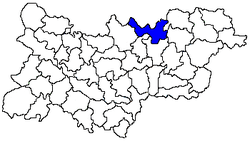 Location of the Ramayampet mandal in the Medak district | |
|
Ramayampet Location in Telangana, India | |
| Coordinates: 18°07′00″N 78°25′47″E / 18.116609°N 78.429766°ECoordinates: 18°07′00″N 78°25′47″E / 18.116609°N 78.429766°E | |
| Country |
|
| State | Telangana |
| District | Medak |
| Population (2001) | |
| • Total | 63,849 |
| Languages | |
| • Official | Telugu |
| Time zone | IST (UTC+5:30) |
| Literacy | 51.37% |
Ramayampet is a town and mandal in Medak district in Indian state of Telangana with a population of 61,809. It is the biggest town in Medak district and is 80 km from Hyderabad.[1]
Geography
Ramayampet is located at 18°07′00″N 78°25′47″E / 18.116609°N 78.429766°E.[2] It has an average elevation of 475 metres (1558 feet). Ramayampet is centrally located between Hyderabad and Nizamabad also between Siddipet and Sangareddy. It has got both National highway, state highway and rail transport system, and Ramayampet also has good education institutes.
Demographics
As of 2001 India census, Ramayampet had a population of 63,849. Males constitute 66% of the population and females 33%. Ramayampet has an average literacy rate of xx%, higher than the national average of 59.5%: male literacy is 64%, and female literacy is 52%. In Ramayampet, 16 Gram Panchayat wards are there.[1]
Politics
It is a heart of Telangana, people here are the hard core fans of Telangana region telangana rastra samithi (T R S) has more number of MPTC, Sarpanches and has good dedicated leaders. and most reputed and great personality who bought electricity to this town (late Shri Nooli Hanumanth Rao) 20 years of his sarpanch life he had developed Ramayampet a lot.
References
- ↑ 1.0 1.1 "List of towns: Census of India 2001". www.censusindia.gov.in. Retrieved 2007-09-24.
- ↑ Falling Rain Genomics, Inc - Ramayampet