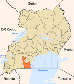
Rakai District
| Rakai District | |
|---|---|
| District | |
 District location in Uganda | |
| Coordinates: 00°43′S 31°24′E / 0.717°S 31.400°ECoordinates: 00°43′S 31°24′E / 0.717°S 31.400°E | |
| Country |
|
| Region | Central Uganda |
| Capital | Rakai |
| Area | |
| • Land | 3,351.5 km2 (1,294.0 sq mi) |
| Population (2012 Estimate) | |
| • Total | 484,400 |
| • Density | 144.5/km2 (374/sq mi) |
| Time zone | EAT (UTC+3) |
| Website |
www |
Rakai District is a district in Central Uganda. Like most other Ugandan districts, it is named after its chief town, Rakai.
Location
Rakai District borders Lyantonde District to the northwest, Lwengo District to the north, Masaka District to the northeast, Kalangala District to the east, the Kagera Region in the Republic of Tanzania to the south, Isingiro District to the southwest and Kiruhura District to the northwest. Rakai, the location of the district headquarters, lies approximately 65 kilometres (40 mi), by road, southwest of Masaka, the largest city in the sub-region.[1] The coordinates of the district are:00 43S, 31 24E.
Overview
Due to its proximity to Uganda's border with Tanzania, the district experiences much cross border commercial traffic to and from Bukoba. The first recorded case of HIV in Uganda was in Rakai District and the district has been particularly hard hit by the disease. A number of medical research facilities are located here. In 2007, the northern part of the district known as Kabula County, was split off to form Lyantonde District.[2]
Population
The 1991 national population census put the district population at about 330,400. In 2002, the next national census estimated the population of the district at approximately 404,330, with an annual growth rate of 1.8%. In 2012, the district population was estimated at about 484,400.[3] The table below is an estimation of how the district population has increased during the first decade of the 21st century.
| Rakai District population trends | ||||||||||||||||||||||||||
|---|---|---|---|---|---|---|---|---|---|---|---|---|---|---|---|---|---|---|---|---|---|---|---|---|---|---|
|
|
| ||||||||||||||||||||||||
Administration
The town of Rakai is the chief municipal, political and administrative center in the district. The headquarters are located in the town. The district is divided into the following administrative units:
- Kakuuto County
- Kooki County
- Kyotera County
- Rakai Town
- Kyotera Town
- Kalisizo Town
Economic activities
Subsistence agriculture is the dominant economic activity in the district, employing over 85% of the people. Crops grown include matooke, beans, cassava and potatoes for food while coffee is the main cash crop. Livestock raised includes cattle, goats, pigs and chicken.
Health issues
The main health issues in the district include:[4] (a) malaria (b) childhood malnutrition (d) diarrheal diseases (c) HIV/AIDS (d) obstetric complications (e) respiratory infections and (e) skin diseases.
Rakai District was the first district to suffer the brunt of the HIV/ADS epidemic in Uganda, back in the early 1980s. Today, more than 30 years later, the district, the country and the international community are still grappling with the effects of that pandemic.[5]
See also
References
- ↑ "Map Showing Masaka And Rakai With Distance Marker". Globefeed.com. Retrieved 9 May 2014.
- ↑ Lyantonde District Established in 2007
- ↑ "Estimated Population of Rakai District In 1991, 2002 & 2012". Citypopulation.de. Retrieved 9 May 2014.
- ↑ Joyce K. Kikafunda, Hanifa K. Namusoke (2006). "Nutritional Status of HIV/AIDS Orphaned Children In Households Headed By The Elderly In Rakai District, South Western Uganda". African Journal of Food, Agriculture, Nutrition and Development Vol. 6(1) 2006 via African Journals Online. Retrieved 9 May 2014.
- ↑ Natukunda, Carol (10 January 2014). "Health: Has The HIV/Aids Fight Lost Steam?". New Vision. Retrieved 9 May 2014.
External links
- Ugandans Fight Aids Depression, BBC, 29 June 2004
- Hospitals in Rakai District
| ||||||||||||||||||