Rakahanga
|
NASA picture of Rakahanga | |
| Geography | |
|---|---|
| Location | Central-Southern Pacific Ocean |
| Coordinates | 10°02′S 161°05′W / 10.033°S 161.083°W |
| Archipelago | Cook Islands |
| Total islands | 11 |
| Major islands |
|
| Area | 4 km2 (1.5 sq mi) |
| Country | |
| Demographics | |
| Population | 127 |
| Density | 32 /km2 (83 /sq mi) |
| Ethnic groups | Nu-matua, Tia-ngaro-tonga |
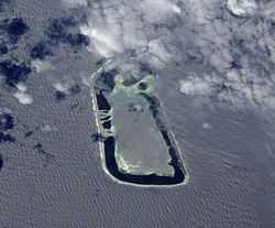
Rakahanga is part of the Cook Islands, lying in the central-southern Pacific Ocean. The unspoilt atoll is 1,248 kilometres from the Cook Islands capital, Rarotonga, and lies 1,111 kilometres from the equator. Its nearest neighbour is Manihiki which is just 44 kilometres away. Rakahanga's population is 127 people on 4 km2.
Geography
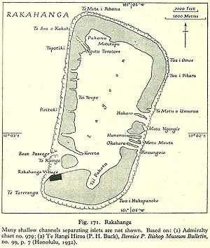
There are four main islands and seven motus or islets in the Rakahanga lagoon. The northern island has divided into three: Tetukono on the north and northeast, Tetaha Kiraro on the west, and Paerangi on the southwest; while the southern island is Rakahanga. The motus are: on the east, Te Motu o Umurua, Akaro, Motu Ngangie, Huananui, Motu Mahuta and Motu Okakara; while on the southwest side the islet of Te Kainga guards the widest passage into the lagoon. The only village, Matara, also called Rakahanga, seat of the Rakahanga Island Council, is on the northwest side of the southern islet, Rakahanga. A newer, official source lists five villages,[1] which may just be the lineages living in the same village:[2]
- Purapoto
- Niteiri
- Numahanga
- Teruakiore
- Matara (main settlement)
The island is just over 4 square kilometres in size and is so low lying that it is in serious danger from rising sea levels.
History
It is believed that Ferdinand Magellan discovered the island in 1521, but this cannot be substantiated by historians who have researched the island's history. One of the last great Spanish voyages of exploration, under the command of Pedro Fernandes de Queirós, came upon the island on 2 March 1606. He noted in a record of the voyage: "The land is divided among many owners, and is planted with certain roots, which must form their bread. All the rest is a large and thick palm grove which is the chief sustenance of the natives. Some 500 inhabitants were seen assembled on the beach". A Franciscan friar, Fray Martin de Munilla, on the voyage was so struck with admiration that he called it the island of beautiful people (gente hermosa).[3] De Quiros described the inhabitants as "the most beautiful white and elegant people that were met during the voyage".
Russian oceanic explorer Fabian Gottlieb von Bellingshausen visited Rakahanga on August 8, 1820, on ships Vostok and Mirni. He took its coordinates and charted its position with accuracy; he named this atoll "Grand Duke Alexander Island", after Grand Duke Alexander Nikolaievich who would later become tsar Alexander II. According to Bellingshausen: "The inhabitants (of Rakahanga) came out in canoes and challenged us to fight by throwing stones and spears at the ship."
Commander A. C. Clarke of HMS Espiegle declared Rakahanga a British protectorate on 9 August 1889. It was included in New Zealand's boundaries in 1901.
The island was claimed under the Guano Islands Act for the United States, a claim which was ceded in a treaty between the U.S. and the Cook Islands in 1980.
Biology
Coconut crabs are abundant in the lagoon, and fishing is good on the outer reef. Large sea turtles abound there too. Each January, a tuna fishing contest takes place and boats return with 200 or more fish a day.
Vegetation is extensive. Large breadfruit trees line village paths and coconut palms and pandanus trees thrive. Women weave fine rito hats, mats and baskets from the pandanus leaf fibres.
People & Culture
Formerly, Rakahanga did not have a well defined population because during depletions of the coconut and puraka supplies, the inhabitants moved between this and Manihiki atoll. In 1852, the settlements were defined on each atoll.
Population
| Historical population | ||
|---|---|---|
| Year | Pop. | ±% |
| 1906 | 352 | — |
| 1911 | 315 | −10.5% |
| 1916 | 295 | −6.3% |
| 1921 | 310 | +5.1% |
| 2008 | 127 | −59.0% |
| Source:"Ethnology of Manihiki and Rakahanga". New Zealand Electronic Text Centre. | ||
A 1916 decrease in population was caused by migrations to Rarotonga Atoll, where employment attracted the former inhabitants. Access to the island is very difficult, other than by boat from Manihiki and by the very occasional inter-island boat. The native tongue is the Rakahanga-Manihiki language.
Tribes
The atoll is populated by two Whakaheo tribes, the Matakeinanga and Tukuwhare. Each one has 7 subtribes, divided in 7 groups:
| Matakeinanga | Tukuwhare |
|---|---|
| Nu-matua |
|
| Tia-ngaro-Tonga |
|
See also
References
- ↑ http://datasearch.uts.edu.au/site_manager_sites/clg/pdfs/CookIslandGovtBill2007.pdf
- ↑ New patterns of settlement | NZETC
- ↑ Kelly, Celsus, O.F.M. La Austrialia del Espiritu Santo. The Journal of Fray Martín de Munilla O.F.M. and other documents relating to the Voyage of Pedro Fernández de Quirós to the South Sea (1605-1606) and the Franciscan Missionary Plan (1617-1627) Cambridge, 1966, p.313.
- ↑ A census view of the Northern islands Cookislands.org.uk
External links
Coordinates: 10°02′S 161°05′W / 10.033°S 161.083°W
| ||||||||||||||||