Rak (creek)
| Rak | |
|---|---|
 Rak in Rakov Škocjan | |
| Origin |
Rakov Škocjan 45°47′27.52″N 14°17′41.19″E / 45.7909778°N 14.2947750°ECoordinates: 45°47′27.52″N 14°17′41.19″E / 45.7909778°N 14.2947750°E |
| Mouth | disappears in Weaver Cave in Rakov Škocjan |
| Basin countries | Slovenia |
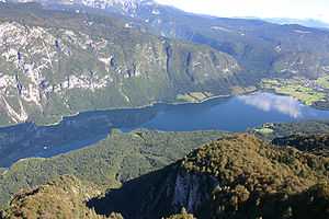
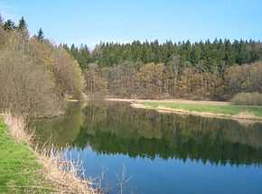
Rak is a creek in Inner Carniola, a traditional region of southeastern Slovenia. It sources in Zelše Caves (Zelške jame) to the west of the village of Zelše,[1] flows across the Rakov Škocjan karst valley for 2 kilometres (1.2 mi) and enters Weaver's Cave (Slovene: Tkalca jama),[2] where it continues for 3 kilometres (1.9 mi) and merges in Planina Cave (Planinska jama), above 300 metres (980 ft) from its entrance, with the Pivka River to form the Unica.[3] The confluence of the Rak and the Pivka is one of the largest subterranean confluences in Europe.[4]
References
- ↑ Javornik, Marjan; Voglar, Dušan; Dermastia, Alenka, eds. (1996). "Zelše". Enciklopedija Slovenije [Encyclopedia of Slovenia] (in Slovenian). p. 153. ISBN 9788611153667.
- ↑ "Mali in Veliki naravni most" [The Big and the Little Natural Bridge]. Www.tdrakek.si (in Slovenian). TD Rakek. Retrieved 17 May 2012.
- ↑ "Rakov Škocjan – Tkalca jama". Kraji.eu. Retrieved 17 May 2012.
- ↑ Kogovšek, Janja; Petrič, Metka; Zupan Hajna, Nadja; Pipan, Tanja. "Planinska jama" [Planina Cave]. In Šmid Hribar, Mateja; Golež, Gregor; Podjed, Dan; Kladnik, Drago; Erhartič, Bojan; Pavlin, Primož; Ines, Jerele. Enciklopedija naravne in kulturne dediščine na Slovenskem [Encyclopedia of Natural and Cultural Heritage in Slovenia] (in Slovenian). Retrieved 17 May 2012.
External links
![]() Media related to Rak (creek) at Wikimedia Commons
Media related to Rak (creek) at Wikimedia Commons
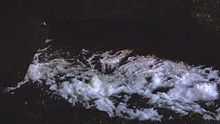
Rak going underground in Tkalca Cave. First part of the video was recorded from the upper entrance of the cave, the second part near the ponor.
| ||||||||||||||||||||||||||||||||||||