Rajec
| Rajec | |
| Town | |
 SNP Square, Rajec | |
| Country | Slovakia |
|---|---|
| Region | Žilina |
| District | Žilina |
| Tourism region | Severné Považie |
| River | Rajčanka |
| Elevation | 452 m (1,483 ft) |
| Coordinates | 49°05′13″N 18°37′58″E / 49.08694°N 18.63278°ECoordinates: 49°05′13″N 18°37′58″E / 49.08694°N 18.63278°E |
| Area | 31.46 km2 (12.15 sq mi) |
| Population | 6,078 (2005-12-31) |
| Density | 193 / km2 (500 / sq mi) |
| First mentioned | 1193 |
| Mayor | Ján Rybárik |
| Timezone | CET (UTC+1) |
| - summer (DST) | CEST (UTC+2) |
| Postal code | 015 01 |
| Area code | +421-41 |
| Car plate | ZA |
  Location of Rajec in Slovakia
| |
  Location of Rajec in the Žilina Region
| |
| Statistics: MOŠ/MIS | |
| Website: www.rajec.sk | |
Rajec (-Slovak and Hungarian, German: Rajetz) is a town in the Žilina District, Žilina Region in northern Slovakia.
History
The first written record about Rajec was in 1193 as Raich, in a document issued by King Béla III. The first mention as a town comes from 1397.
Geography
Rajec lies at an altitude of 452 metres (1,483 ft) above sea level and covers an area of 31.459 square kilometres (12.1 sq mi).[1] It is situated between Strážovské vrchy and Malá Fatra mountains, in the Rajčanka river valley, around 20 km (12 mi) south-south-west of Žilina.
Demographics
According to the 2001 census, the town had 6,074 inhabitants. 98.86% of inhabitants were Slovaks and 0.68% Czechs.[1] The religious make-up was 92.79% Roman Catholics, 3.42% people with no religious affiliation and 1.89% Lutherans.[1]
Sightseeings
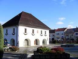
- Town Hall, renesainsse one-floor building available from all sides. Open arcades served like market. On the second floor, there were administrative rooms of town council. After the newest reconstruction in 1992, the arcades are full glassed and the town hall serve as wedding, concert and exhibition room. (3D Model)
- Town museum, former brewery residence
Twin cities
-
 Krnov, Moravian–Silesian Region, Czech Republic
References
- ↑ 1.0 1.1 1.2 "Municipal Statistics". Statistical Office of the Slovak republic. Archived from the original on 2008-01-11. Retrieved 2008-01-31.
External links
| Wikimedia Commons has media related to Rajec. |