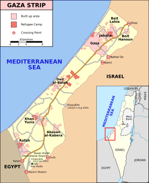
Rafah
| Rafah | |
|---|---|
| Other transcription(s) | |
| • Arabic | رفح |
| • Hebrew | רָפִיחַ |
 Rafah Location of Rafah within Palestine | |
| Coordinates: 31°17′19″N 34°15′07″E / 31.28861°N 34.25194°ECoordinates: 31°17′19″N 34°15′07″E / 31.28861°N 34.25194°E | |
| Palestine grid | 77/78 |
| Governorate | Rafah |
| Government | |
| • Type | City |
| • Head of Municipality | Sa'ad Zoarub |
| Population (2014)[1] | |
| • Jurisdiction | 152,950 |
Rafah (Arabic: رفح;[2] Rafiah;[3] officially مخَيَّم رَفَحْ;[4] Mukhayyam Rafaḩ[5]), is a Palestinian city and refugee camp in the southern Gaza Strip. Located 30 kilometers (19 mi) south of Gaza, Rafah's population of 152,950 (2014) is overwhelmingly made up of Palestinian refugees. Rafah camp and Tall as-Sultan camp form separate localities. Rafah is the district capital of the Rafah Governorate. Yasser Arafat International Airport, Gaza's only airport, is located just south of the city; the airport operated from 1998 to 2001, when it was bombed and bulldozed by the Israeli military (IDF) after the killing of Israeli soldiers by members of Hamas. Rafah is the site of the Rafah Border Crossing, the main crossing between the Gaza Strip and Egypt.
Etymology
Over the ages it has been known as "Robihwa" by the ancient Egyptians, "Rafihu" by the Assyrians, "Ῥαφία, Rhaphia"[6] by the Greeks, "Raphia" by Romans, רפיח "Raphiaḥ" [pronounced Rafiach] by the Israelites, "Rafh" by the Arab Caliphate.
History
Rafah has a history stretching back thousands of years. It was first recorded in an inscription of Egyptian Pharaoh Seti I, from 1303 BCE as Rph, and as the first stop on Pharaoh Shoshenq I's campaign to the Levant in 925 BC. In 720 BCE it was the site of the Assyrian king Sargon II's victory over the Egyptians, and in 217 BC the Battle of Raphia was fought between the victorious Ptolemy IV and Antiochus III.[7] (It is said to be one of the largest battles ever fought in the Levant, with over a hundred thousand soldiers and hundreds of elephants).
The town was conquered by Alexander Yannai and held by the Hasmoneans until it was rebuilt in the time of Pompey and Gabinius; the latter seems to have done the actual work of restoration for the era of the town dates from 57 BCE. Rafah is mentioned in Strabo (16, 2, 31), the Antonine Itinerary, and is depicted on the Map of Madaba.[7]
During the Byzantine period, it was a diocese,[7] and Byzantine ceramics and coins have been found there.[8]
Arab and Mamluk rule
Rafah was an important trading city during the early Arab period, and one of the towns captured by the Rashidun army under general 'Amr ibn al-'As in 635 CE.[9] Under the Umayyads and Abbasids, Rafah was the southernmost border of Jund Filastin ("District of Palestine"). According to Arab geographer al‑Ya'qubi, it was the last town in the Province of Syria and on the road from Ramla to Egypt.[10]
A Jewish community settled in the city in the 9th and 10th centuries and again in the 12th, although in the 11th century it suffered a decline and in 1080 they migrated to Ashkelon. A Samaritan community also lived there during this period. Like most cities of southern Palestine, ancient Rafah had a landing place on the coast (now Tell Rafah), while the main city was inland.[7]
In 1226, Arab geographer Yaqut al-Hamawi writes of Rafah's former importance in the early Arab period, saying it was "of old a flourishing town, with a market, and a mosque, and hostelries". However, he goes on to say that in its current state, Rafah was in ruins, but was an Ayyubid postal station on the road to Egypt after nearby Deir al‑Balah.[10]
Ottoman and Egyptian period
Rafah appeared in the 1596 Ottoman tax registers as being in the Nahiya of Gaza of the Liwa of Gazza. It had a population of 15 households, all Muslim, who paid taxes on wheat, barley, summer crops, occasional revenues, goats and/or bee hives.[11]
In 1799, the Revolutionary Army of France commanded by Napoleon Bonaparte passed through Rafah during the invasion of Egypt and Syria.[12]
Rafah was the boundary between the provinces of Egypt and Syria. In 1832, the area came under Egyptian occupation of Muhammad Ali, which lasted until 1840.
The French explorer Victor Guérin, who visited in May 1863, noted two pillars of granite which the locals called Bab el Medinet, meaning "The Gate of the town".[13] In 1881, Archduke Ludwig Salvator of Austria wrote: "Fragments of gray granite pillars, still standing, are here to be met with about the road, the fields, and the sand, and we saw one lying on the ground half buried... The pillars are the remains of an ancient temple, Raphia, and are of special importance in the eyes of the Arabs, who call them Rafah, as they mark the boundary between Egypt and Syria."[14]
British mandate era
In 1917, the British army captured Rafah, and used it as a base for their attack on Gaza. The presence of the army bases was an economic draw that brought people back to the city.
In the 1922 census of Palestine conducted by the British Mandate authorities, Rafah had a population of 599, all Muslim,[15] increasing in the 1931 census to 1,423, still all Muslims, in 228 houses.[16]
In 1945 Rafah had a population of 2,220, all Arabs, with 40,579 dunams of land, according to an official land and population survey.[17] Of this, 275 dunams were plantations and irrigable land, 24,173 used for cereals,[18] while 16,131 dunams were un-cultivable land.[19]
1948, and after

After the 1948 Arab-Israeli War, the refugee camps were established. In the 1956 war involving Israel, Britain, France, and Egypt, 111 people, including 103 refugees, were killed by the Israeli army in the Palestinian refugee camp of Rafah, during the Rafah massacre. The United Nations was unable to determine the circumstances surrounding the deaths.[20][21]
During the 1967 Six-Day War, the Israel Defense Forces captured Rafah with the Sinai Peninsula and Gaza Strip, the population was about 55,000, of whom only 11,000 lived in Rafah itself.
In the summer of 1971, the IDF, under General Ariel Sharon (then head of the IDF southern command), destroyed approximately 500 houses in the refugee camps of Rafah in order to create patrol roads for Israeli forces. These demolitions displaced nearly 4000 people.[22] Israel established the Brazil and Canada housing projects to accommodate displaced Palestinians and to provide better conditions in the hopes of integrating the refugees into the general population and its standard of living;[23] Brazil is immediate south of Rafah, while Canada was just across the border in Sinai. Both were named because UN peacekeeping troops from those respective countries had maintained barracks in those locations. After the 1978 Camp David Accords mandated the repatriation of Canada project refugees to the Gaza Strip, the Tel al-Sultan project, northwest of Rafah, was built to accommodate them.[24]
Because of the Camp David Accords, Israel withdrew from the Sinai Peninsula and Rafah was divided, with part of it on the Egyptian side of the border under Egyptian rule. To cope with the division of the town, smugglers made tunnels under the border, connecting the two parts and permitting the smuggling of goods and persons.[25]
Demographics
In 1922, Rafah's population was 599,[15] which increased to 2,220 in 1945.[17] In 1982, the total population was approximately 10,800.[26]
In the 1997 Palestinian Central Bureau of Statistics (PCBS) census, Rafah and its adjacent camp had a combined population of 91,181, Tall as-Sultan was listed with a further 17,141.[27] Refugees made up 80.3% of the entire population.[28] In the 1997 census, Rafah's (together with Rafah camp) gender distribution was 50.5% male and 49.5% female.[29]
In the 2006 PCBS estimate, Rafah city had a population of 71,003,[30] Rafah camp and Tall as-Sultan form separate localities for census purposes, having populations of 59,983 and 24,418, respectively.[30]
Rafah Border Crossing
Rafah is the site of the Rafah Border Crossing, the main crossing between the Gaza Strip and Egypt. Formerly operated by Israeli military forces, control of the crossing was transferred to the Palestinian Authority in September 2005 as part of the larger Israeli withdrawal from the Gaza Strip. A European Union commission began monitoring the crossing in November 2005 amid Israeli security concerns, and in April 2006, Palestinian Authority Chairman Mahmoud Abbas's Presidential Guard assumed responsibility for the site on the Palestinian Authority side.[31] On the Egyptian side, the responsibility is assumed by the 750 Border Guards allowed by an agreement of Egypt with Israel. The agreement was signed in November 2005 forced by US pressure, and specifies that it is under security requirements demanded by Israel.
Climate
Köppen-Geiger climate classification system classifies its climate as hot semi-arid (BSh).[32][33]
| Climate data for Rafiah, Gaza Strip | |||||||||||||
|---|---|---|---|---|---|---|---|---|---|---|---|---|---|
| Month | Jan | Feb | Mar | Apr | May | Jun | Jul | Aug | Sep | Oct | Nov | Dec | Year |
| Average high °C (°F) | 17.4 (63.3) |
18.1 (64.6) |
20.5 (68.9) |
23 (73) |
25.8 (78.4) |
28.3 (82.9) |
29.6 (85.3) |
30.5 (86.9) |
29.1 (84.4) |
27.6 (81.7) |
23.8 (74.8) |
19.4 (66.9) |
24.42 (75.93) |
| Daily mean °C (°F) | 12.9 (55.2) |
13.6 (56.5) |
15.6 (60.1) |
18.1 (64.6) |
20.9 (69.6) |
23.6 (74.5) |
25.2 (77.4) |
26 (79) |
24.7 (76.5) |
22.6 (72.7) |
18.7 (65.7) |
14.8 (58.6) |
19.72 (67.53) |
| Average low °C (°F) | 8.4 (47.1) |
9.1 (48.4) |
10.8 (51.4) |
13.3 (55.9) |
16.1 (61) |
19 (66) |
20.9 (69.6) |
21.6 (70.9) |
20.3 (68.5) |
17.6 (63.7) |
13.7 (56.7) |
10.2 (50.4) |
15.08 (59.13) |
| Average precipitation mm (inches) | 48 (1.89) |
36 (1.42) |
27 (1.06) |
6 (0.24) |
4 (0.16) |
0 (0) |
0 (0) |
0 (0) |
0 (0) |
8 (0.31) |
39 (1.54) |
53 (2.09) |
221 (8.71) |
| Source: Climate-Data.org (altitude: 45m)[32] | |||||||||||||
| Climate data for Rafah, North Sinai | |||||||||||||
|---|---|---|---|---|---|---|---|---|---|---|---|---|---|
| Month | Jan | Feb | Mar | Apr | May | Jun | Jul | Aug | Sep | Oct | Nov | Dec | Year |
| Average high °C (°F) | 17.2 (63) |
18 (64) |
20.3 (68.5) |
22.9 (73.2) |
25.8 (78.4) |
28.2 (82.8) |
29.6 (85.3) |
30.5 (86.9) |
29 (84) |
27.4 (81.3) |
23.7 (74.7) |
19.3 (66.7) |
24.33 (75.73) |
| Daily mean °C (°F) | 12.7 (54.9) |
13.5 (56.3) |
15.4 (59.7) |
18 (64) |
20.8 (69.4) |
23.5 (74.3) |
25.2 (77.4) |
25.9 (78.6) |
24.5 (76.1) |
22.4 (72.3) |
18.6 (65.5) |
14.7 (58.5) |
19.6 (67.25) |
| Average low °C (°F) | 8.2 (46.8) |
9 (48) |
10.6 (51.1) |
13.2 (55.8) |
15.9 (60.6) |
18.8 (65.8) |
20.8 (69.4) |
21.4 (70.5) |
20 (68) |
17.4 (63.3) |
13.5 (56.3) |
10.1 (50.2) |
14.91 (58.82) |
| Average precipitation mm (inches) | 49 (1.93) |
37 (1.46) |
28 (1.1) |
6 (0.24) |
4 (0.16) |
0 (0) |
0 (0) |
0 (0) |
0 (0) |
8 (0.31) |
39 (1.54) |
54 (2.13) |
225 (8.87) |
| Source: Climate-Data.org (altitude: 78m)[33] | |||||||||||||
See also
- Battle of Gaza (2007)
- European Union Border Assistance Mission Rafah
- Israel and Egypt – Gaza Strip barrier
- Philadelphi Corridor
- Rafah Elementary Co-Ed “B” School
- Rafah Governorate
- Asma al-Ghul
References
- ↑ Palestinian Central Bureau of Statistics
- ↑ "رفح: Gaza Strip; name, map, geographic coordinates". Geographic.org. Retrieved 2014-08-11.
- ↑ "Rafīah: Gaza Strip; name, map, geographic coordinates". Geographic.org. Retrieved 2014-08-11.
- ↑ "مخَيَّم رَفَحْ: Gaza Strip; name, map, geographic coordinates". Geographic.org. Retrieved 2014-08-11.
- ↑ "Mukhayyam Rafaḩ: Gaza Strip; name, map, geographic coordinates". Geographic.org. Retrieved 2014-08-11.
- ↑ Polybii Historiae [5,80].
- ↑ 7.0 7.1 7.2 7.3 Raphia - (Rafah) Studium Biblicum Franciscanum - Jerusalem.
- ↑ Dauphin, 1998, p. 953
- ↑ al‑Biladhuri quoted in le Strange, 1890, p. xix. Al-Biladhuri lists the cities captured by Amr ibn al-'As as Ghazzah (Gaza), Sebastiya (Sebastia), Nabulus, Amwas (Imwas), Kaisariyya (Caesarea), Yibna, Ludd (Lydda), Rafh (Rafah), Bayt Jibrin, and Yaffa (Jaffa). Cited in le Strange, 1890, p. 28
- ↑ 10.0 10.1 le Strange, 1890, p. 517
- ↑ Hütteroth and Abdulfattah, 1977, p. 150
- ↑ Dwyer, 2007, p. 415
- ↑ Guérin, 1869, pp. 233-35
- ↑ Ludwig Salvator, Archduke of Austria, 1881, p. 54
- ↑ 15.0 15.1 Barron, 1923, Table V, Sub-district of Gaza, p. 8
- ↑ Mills, 1932, p. 6
- ↑ 17.0 17.1 Government of Palestine, Department of Statistics. Village Statistics, April, 1945. Quoted in Hadawi, 1970, p. 46
- ↑ Government of Palestine, Department of Statistics. Village Statistics, April, 1945. Quoted in Hadawi, 1970, p. 88
- ↑ Government of Palestine, Department of Statistics. Village Statistics, April, 1945. Quoted in Hadawi, 1970, p. 138
- ↑ http://unispal.un.org/UNISPAL.NSF/0/6558F61D3DB6BD4505256593006B06BE
- ↑ http://cosmos.ucc.ie/cs1064/jabowen/IPSC/php/place.php?plid=210
- ↑ UN Doc A/8389 of 5 October 1971 (h) The continued transfer of the population of the occupied territories to other areas within the occupied territories. Such transfers of population have occurred in the case of several villages that were systematically destroyed in 1967: the population of these villages was either expelled or forced to live elsewhere in the occupied territories. The same practice has been followed in occupied Jerusalem. According to a report in the Jerusalem Post of 17 May 1971, Mr. Teddy Kollek, Israeli Mayor of Jerusalem, stated that 4,000 Arabs had been evacuated from Jerusalem. Likewise, in the case of Gaza, according to reports appearing in several newspapers and in letters addressed by Governments, several thousands of persons were displaced from the three major refugee camps in Gaza. Official Israeli sources have stated that these transfers of population were necessitated by new security measures, such as the construction of wider roads inside the camps in order to facilitate patrolling and the maintenance of law and order in the camps. Most of the persons whose refugee accommodation was destroyed to permit of the construction of these roads were forced to leave for the West Bank and El Arish, while a few were said to have sought refuge with other families inside Gaza. The Special Committee considers that the transfers were unwarranted and that even if the construction of new roads was considered indispensable for the maintenance of law and order, the arbitrary transfer of population was unnecessary, unjustified and in breach of the Fourth Geneva Convention.
- ↑ http://www.shaml.org/publications/monos/mono4.htm
- ↑ Human Rights Watch. Razing Rafah: Mass Home Demolitions in the Gaza Strip. October 2004.
- ↑ About Rafah Rafah Today.
- ↑ Welcome to Rafah Palestine Remembered.
- ↑ Palestinian Population by Locality, Sex and Age Groups in Years
- ↑ Palestinian Population by Locality and Refugee Status. Palestinian Central Bureau of Statistics (PCBS).
- ↑ Palestinian Population by Locality, Sex and Age Groups in Years Palestinian Central Bureau of Statistics.
- ↑ 30.0 30.1 PCBS [Palestinian Central Bureau of Statisctics (PCBS) Projected Mid-Year Population for Rafah Governorate by Locality 2004-2006]
- ↑ Mitch Potter, Something that works: the Rafah crossing, The Toronto Star, May 21, 2006.
- ↑ 32.0 32.1 "Climate: Rafiah - Climate graph, Temperature graph, Climate table". Climate-Data.org. Retrieved 2014-02-21.
- ↑ 33.0 33.1 "Climate: Rafah - Climate graph, Temperature graph, Climate table". Climate-Data.org. Retrieved 2014-02-21.
Bibliography
| Wikimedia Commons has media related to Rafah. |
- Archduke of Austria, Ludwig Salvator (1881). The Caravan Route between Egypt and Syria. London: Chatto & Windus.
- Barron, J. B., ed. (1923). Palestine: Report and General Abstracts of the Census of 1922. Government of Palestine.
- Dauphin, Claudine (1998). La Palestine byzantine, Peuplement et Populations. BAR International Series 726 (in French). III : Catalogue. Oxford: Archeopress.
- Dwyer, Philip (2007). Napoleon -The Path To Power 1769-1799. Bloomsbury. ISBN 0747574901.
- Guérin, Victor (1869). Description Géographique Historique et Archéologique de la Palestine (in French). 1: Judee, pt. 2. Paris: L'Imprimerie Nationale.
- Hadawi, Sami (1970), Village Statistics of 1945: A Classification of Land and Area ownership in Palestine, Palestine Liberation Organization Research Center
- Hütteroth, Wolf-Dieter; Abdulfattah, Kamal (1977). Historical Geography of Palestine, Transjordan and Southern Syria in the Late 16th Century. Erlanger Geographische Arbeiten, Sonderband 5. Erlangen, Germany: Vorstand der Fränkischen Geographischen Gesellschaft. ISBN 3-920405-41-2.
- Mills, E., ed. (1932). Census of Palestine 1931. Population of Villages, Towns and Administrative Areas. Jerusalem: Government of Palestine.
- Strange, le, Guy (1890). Palestine Under the Moslems: A Description of Syria and the Holy Land from A.D. 650 to 1500. Committee of the Palestine Exploration Fund.
External links
- United Nations Relief and Works Agency for Palestine Refugees in the Near East
- Welcome To The City of Rafah
- Rafah Today, pictures by Palestinian journalist Mohammed Omer
- Rafah Smuggling Tunnels
- Rafah Pundits: Rafah Focused Blog
- Raising Yousuf - Blog by Laila el-Hadad who is a reporter for Aljazeera living in Gaza
- Reports from Rafah
- Interview with Hip Hop Artist Michael Franti - Reporting from Rafah.
- Part A Part B Satellite photos comparing 2001 to 2004.
- Razing Rafah: Mass Home Demolitions in the Gaza Strip - Human Rights Watch
- The Olympia-Rafah Sister City Project - The organization started by people in the communities of Rafah, Gaza, and Olympia, WA
- The Madison-Rafah Sister City Project - A sistering project connecting the communities of Rafah, Gaza, and Madison, WI
| ||||||||||||||||||
| ||||||||||||||||||||