Radymno
| Radymno | ||
|---|---|---|
|
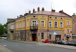
Buildings downtown | ||
| ||
 Radymno | ||
| Coordinates: 49°57′0″N 22°48′59″E / 49.95000°N 22.81639°E | ||
| Country |
| |
| Voivodeship |
| |
| County | Jarosław | |
| Gmina | Radymno (urban gmina) | |
| Founded | 1366 | |
| City rights | 1431 | |
| Government | ||
| • Mayor | Wiesław Pirożek | |
| Area | ||
| • Total | 13.59 km2 (5.25 sq mi) | |
| Elevation | 202.5 m (664.4 ft) | |
| Population (2006) | ||
| • Total | 5,603 | |
| • Density | 410/km2 (1,100/sq mi) | |
| Time zone | CET (UTC+1) | |
| • Summer (DST) | CEST (UTC+2) | |
| Postal code | 37-550 | |
| Car plates | RJA | |
| Website | http://www.radymno.pl/index.php | |

Radymno [raˈdɨmnɔ] (Ukrainian: Радимно, Radymno) is a town in south-eastern Poland with 5,543 inhabitants (02.06.2009).[1] It has been part of the Subcarpathian Voivodeship since its creation in 1999. Radymno was previously in the Przemyśl Voivodeship from 1975–1998.
History
First traces of human settlement in what today is Radymno date back to the Neolothic times, as in 1958, archaeologists found remains of a 2nd-century settlement. In early Middle Ages, the area was part of Polish state, but in 981, it was seized by Kievan Rus. Together with whole Red Ruthenia, Radymno was annexed by Polish King Kazimierz Wielki in mid-14th century.
In 1366, a nobleman Bernard of Szynwald received permission from Kazimierz Wielki to establish a settlement in the fields. In 1384, Radymno was presented to the Bishops of Przemysl, and in 1431 King Wladyslaw Jagiello gave town charter to the village. Due to its location by the San river, and along a busy merchant route, Radymno was an important trade and market center. The town, however, was looted by Wallachians (1488) and Crimean Tatars (1502, 1624). Furthermore, it burned in fires (1603, 1638, 1647). To protect it from further raids, Radymno was fortified in 1625, but in 1656 it was captured by Swedes, and in 1657 by Transilvanians (see Swedish invasion of Poland). Swedish wars left Radymno in ruins, and the town for many years did not recover from widespread destruction. In late July 1683, the army of Hetman Stanislaw Jablonowski camped near Radymno, on its way towards Vienna (see Battle of Vienna).
In the second half of the 18th century, before the Partitions of Poland, the population of Radymno was 1200, with 154 houses, three churches, hospital, parish school, two brickyards, and a residence of the Bishops of Przemysl.
In the middle of 18th century, Radymno had a population of 860 Roman Catholics, 196 people of Greek Catholic faith, and 26 Jews.[2] As a result of the first of Partitions of Poland (Treaty of St-Petersburg dated 5 July 1772, Radymno (and the Galicia) was attributed to the Habsburg Monarchy.[3] It was part of the Bezirkshauptmannschaft Jaroslau (Jarosław County).[4] For more details, see the article Kingdom of Galicia and Lodomeria. Radymno remained in Galicia until November 1918.
In 1860, Radymno received rail connection with Przemysl. Austrian government for a while considered construction of a fortress here, but changed their minds and created Fortress Przemysl instead. In 1857–1867 Radymno was the seat of a county. In late 19th century, the town had the population of 2700.
On May 24, 1915, the Battle of Radymno took place between Russian 8th Army of General Aleksei Brusilov, and German-Austrian 8th Army under General August von Mackensen. The town was almost completely destroyed.
In the Second Polish Republic, Radymno belonged to Lwow Voivodeship, with a mixed Polish - Jewish population of 2500. On September 10, 1939, during the Invasion of Poland, German 4th Light Division crossed the San here, after a battle with Polish Army’s Jaroslaw Group under Colonel Jan Wojciak. During the war, groups of the Organization of Ukrainian Nationalists, which operated in the area, murdered 59 Poles, including 29 killed in the village of Michalowka. Radymno was captured by the Red Army on July 26, 1944, after heavy fighting with German armoured units.
External links
References
- ↑ "Population. Size and structure by territorial division". © 1995-2009 Central Statistical Office 00-925 Warsaw, Al. Niepodległości 208. 2009-06-02. Retrieved 2009-06-22.
- ↑ J. Motylkiewicz. "Ethnic Communities in the Towns of the Polish-Ukrainian Borderland in the Sixteenth, Seventeenth, and Eighteenth Centuries". C. M. Hann, P. R. Magocsi ed. Galicia: A Multicultured Land. University of Toronto Press. 2005. p. 37.
- ↑ Atlas des peuples d'Europe centrale, André et Jean Sellier, 1991, p.88
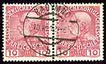
- ↑ Die postalischen Abstempelungen auf den österreichischen Postwertzeichen-Ausgaben 1867, 1883 und 1890, Wilhelm KLEIN, 1967
Coordinates: 49°57′N 22°49′E / 49.950°N 22.817°E
| ||||||||||||
| ||||||||||